
Class X: Chapter 7 (Lifelines of National Economy)
Objectives and Goals:
1. What is the lifeline to national economy?
2. Who are the traders?
3. World into Global Village.
4. Transportation, Communication and Trade, impact on national economy.
5. Different means of Transportation: Land, Water and Air.
6. Land: Roadways and Railways.
7. Roadways: Golden Quadrilateral Super Highways, National Highways, State Highways, District Highways, Other Roads and border roads.
8. Road Density.
9. Railways: Rail network, Rail gauge and length of routes in India, Development of railways
10. Pipelines.
11. Waterways.
12. Major Sea Ports
13. Airway
14. Major International Airports
15. Communication
16. International Trade
17. Tourism as a Trade
There are three types of economic activities. These are:
1. Primary Activities: Connected with extraction and production of natural resources like forestry, agriculture, mining, animal husbandry, etc.
2. Secondary Activities: Connected with processing and manufacturing of primary goods into finished goods. They get raw material from the Primary sector. For e.g. Iron ore into tools & machines, sugar cane into sugar, etc.
3. Tertiary Activities: Provides support to Primary and Secondary sectors through services, e.g. transportation, banking, tourism, etc.
Lifelines of National Economy:
• Transport plays an important role in the economy.
• Because of transport raw materials reach the factory and finished products reach to the consumer.
• The pace of development of a country depends upon the production of goods and services as well as their movement over space.
• Therefore, efficient means of transport are pre-requisites for fast development.
• Apart from transport, the ease and mode of communications, like telephone and internet makes seamless flow of information possible.
• Today, India is well-linked with the rest of the world despite its vast size, diversity and linguistic and socio-cultural plurality.
• Railways, airways, waterways, newspapers, radio, television, cinema and internet, etc. have been contributing to its socio-economic progress in many ways.
• The trades from local to international levels have added to the vitality of its economy.
• It has enriched our life and added substantially to growing amenities and facilities for the comforts of life.
ROADWAYS:
• India has one of the largest road networks in the world, aggregating to about 2.3 million km at present.
• In India, roadways have preceded railways.
• They still have an edge over railways in view of the ease with which they can be built and maintained.
• The growing importance of road transport against the transport is rooted in the following reasons:
(a) Construction cost of roads is much lower than that of railway lines.
(b) Roads can pass through comparatively more dissected and undulating topography.
(c) Roads can negotiate higher gradients of slopes and as such can traverse mountains such as the Himalayas.
(d) Road transport is economical in transportation of few persons and relatively smaller amount of goods over short distances.
(e) It also provides door-to-door service, thus the cost of loading and unloading is much lower.
(f) Road transport is also used as a feeder to other modes of transport such as they provide a link between railway stations, air and sea ports.
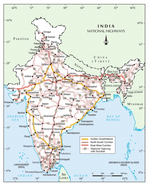
In India, roads are classified in the following six classes according to their capacity:
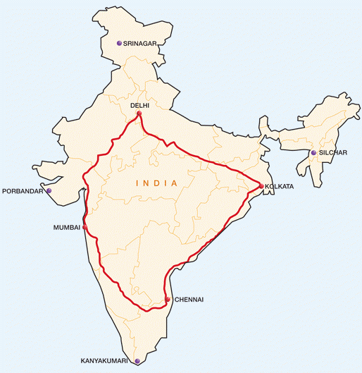
(a) Golden Quadrilateral:
To know more about the Golden Quadrilateral Super Highways in India, please click on the link given below:
https://www.youtube.com/watch?v=aZLpyLl-0-E
• The government has launched a major road development project linking Delhi-Kolkata- Chennai-Mumbai and Delhi by six-lane super highways.
• The north-south corridors linking Srinagar (Jammu & Kashmir) and Kanyakumari (Tamil Nadu), and east-west corridor connecting Silcher (Assam) and Porbander (Gujarat) are part of this project.
• The major objective of these super highways is to reduce the time and distance between the mega cities of India.
• These highway projects are being implemented by the National Highway Authority of India (NHAI).
(b) National Highways:
• National highways link extreme parts of the country.
• These are the primary road systems and are laid and maintained by the Central Public Works Department (CPWD).
• A number of major national highways run in north-south and east-west directions.
(c) State Highways:
• Roads linking a state capital with different district headquarters are known as state highways.
• These roads are constructed and maintained by the state Public Works Department (PWD) in state and union territories.
(d) District Roads:
• These roads connect the district headquarters with other places of the district.
• These roads are maintained by the Zila Parishad.
(e) Other Roads:
• Rural roads, which link rural areas and villages with towns, are classified under this category.
• These roads received special momentum under the Pradhan Mantri Grameen Sadak Yojana.
• Under this scheme special provisions are made so that every village in the country is linked to a major town in the country by an all season motorable road.
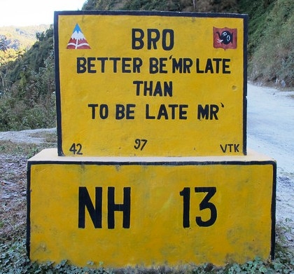
(f) Border Roads:
• Apart from these, Border Roads Organization a government of India undertaking constructs and maintains roads in the bordering areas of the country.
• This organization was established in 1960 for the development of the roads of strategic importance in the northern and northeastern border areas.
• These roads have improved accessibility in areas of difficult terrain and have helped in the economic development of these areas.
Roads can also be classified on the basis of the type of material used:
(a) Metalled Road.
(b) Unmetalled Road.
(a) Metalled Road: These roads can be made of Cement, Concrete or even bitumen of coal, therefore, these are all weather roads.
(b) Unmetalled Road: These roads go out of use in the rainy season.
Road Density:
• The length of road per 100 sq. Km of area is known as density of roads.
• Distribution of road is not uniform in the country.
• Density of all roads varies from only 10.04 km in Jammu & Kashmir to 532.27 km in Uttar Pradesh (2007-08) with national average of 125.02 km (2007-08).
• In the year 1996-97, the national average density of road was 75 km.
• Road transportation in India faces a number of problems.
• Keeping in view the volume of traffic and passengers, the road network is inadequate.
• About half of the roads are unmetalled and this limits their usage during the rainy season.
• The national highways are inadequate too.
• Moreover, the roadways are highly congested in cities and most of the bridges and culverts are old and narrow.
• In the recent years, fast development of road network has taken place in different parts of India.
RAILWAYS
• Railways are the most important mode of transportation for freight and passengers in India.
• Railways also make it possible to conduct different activities like business, sightseeing, pilgrimage, etc. along with transportation of goods over longer distances.
• Apart from an important means of transportation the Indian railways have been a great integrating force for more than 150 years.
• The first train ran between Mumbai to Thane in the year 1853 covering an area of 34 kms.
• Railways in India bind the economic life of the country as well as accelerate the development of the industry and agriculture.
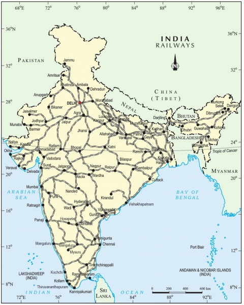
Rail Network:
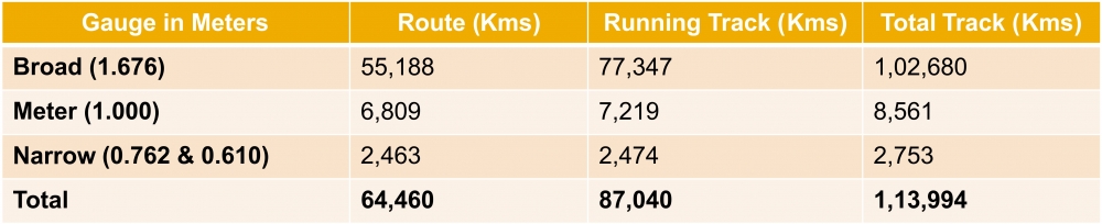
• The Indian railways have a network of 7,133 stations spread over a route length of 64,460 km.
• With a fleet of 9,213 locomotives,
• 53,220 passenger service vehicles,
• 6,493 other coach vehicles and 2,29,381 wagons as on March 2011.
DISTRIBUTION OF RAILWAYS
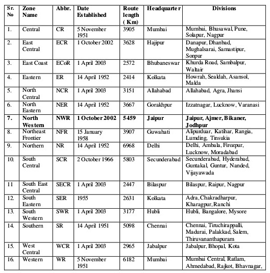
• The Indian railway is now reorganized into 16 zones.
To know more about the Zonal Headquarters of Indian Railways, please click on the link given below:
https://www.youtube.com/watch?v=zOZDEeHK4dE&t=16s
Development of Railways:
1. The distribution pattern of the railway network in the country has been largely influenced by physiographic, economic and administrative factors.
2. The northern plains with their vast level land, high population density and rich agricultural resources provided the most favourable condition for their growth. However, a large number of rivers requiring construction of bridges across their wide beds posed some obstacles.
3. In the hilly terrains of the peninsular region, railway tracts are laid through low hills, gaps or tunnels.
4. The Himalayan mountainous regions too are unfavourable for the construction of railway lines due to high relief, sparse population and lack of economic opportunities.
5. Likewise, it was difficult to lay railway lines on the sandy plain of western Rajasthan, swamps of Gujarat, forested tracks of Madhya Pradesh, Chhattisgarh, Orissa and Jharkhand.
6. The contiguous stretch of Sahyadri could be crossed only through gaps or passes (Ghats).
7. In recent times, the development of the Konkan railway along the west coast has facilitated the movement of passengers and goods in this most important economic region of India. It has also faced a number of problems such as sinking of track in some stretches and landslides.
8. Today, the railways have become more important in our national economy than all other means of transport put together.
9. However, rail transport suffers from certain problems as well:
(a) Many passengers travel without tickets.
(b) Thefts and damaging of railway property has not yet stopped completely.
(c) People stop the trains, pull the chain unnecessarily and this causes heavy damage to the railway.
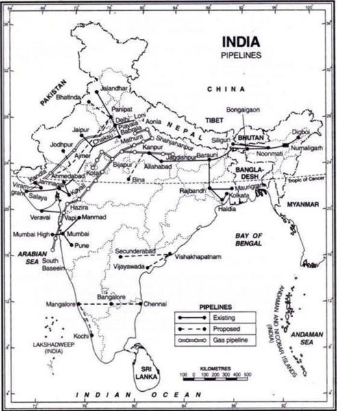
PIPELINES
• Pipeline transport network is a new arrival on the transportation map of India.
• In the past, these pipelines were used to transport water to cities and industries.
• Now, these are used for transporting crude oil, petroleum products and natural gas from oil and natural gas fields to refineries, fertilizer factories and big thermal power plants.
• Solids can also be transported through a pipeline when converted into slurry.
• The far inland locations of refineries like Barauni, Mathura, Panipat and gas based fertilizer plants could be thought of only because of pipelines.
• Initial cost of laying pipelines is high but subsequent running costs are minimal.
• It rules out trans-shipment losses or delays.
To know more about the three Major Pipeline Networks in India, please click on the link given below:
https://www.youtube.com/watch?v=fgmUCWI7-Ng
There are three important networks of pipeline transportation in the country:
(a) From oil field in upper Assam to Kanpur (Uttar Pradesh), via Guwahati, Barauni and Allahabad. It has branches from Barauni to Haldia, via Rajbandh, Rajbandh to Maurigram and Guwahati to Siliguri.
(b) From Salaya in Gujarat to Jalandhar in Punjab, via Viramgam, Mathura, Delhi and Sonipat. It has branches to connect Koyali (near Vadodara, Gujarat) Chakshu and other places.
(c) Gas pipeline from Hazira in Gujarat connects Jagdishpur in Uttar Pradesh, via Vijaipur in Madhya Pradesh. It has branches to Kota in Rajasthan, Shahajahanpur, Babrala and other places in Uttar Pradesh.
WATERWAYS
• Waterways are the cheapest means of transport.
• They are most suitable for carrying heavy and bulky goods.
• It is a fuel-efficient and environment friendly mode of transport.
• India has inland navigation waterways of 14,500 km in length.
• Out of these only 5,685 km are navigable by mechanized boats.
• The following waterways have been declared as the national waterways by the government:
(a) The Ganga river between Allahabad and Haldia (1620 km) - N.W. No. 1
(b) The Brahmaputra river between Sadiya and Dhubri (891 km) – N.W. No. 2
(c) The west-coast canal in Kerala (Kottapurma - Kollam, Udyogamandal and Champakkara canals) - 205 km – N.W. No. 3
(d) Specified stretches of the Godavari, Krishna rivers alongwith Kakinada, Puducherry stretch of canals – 1078 km – N.W. No – 4
(e) Specified stretches of the river Brahmani along with Matai river, delta channels of Mahanadi and Brahmani rivers and east coast canal – 588 km – N.W. No - 5
(f) There are some other inland waterways, like: Mandavi, Zuari and Cumberjua, Sunderbans, Barak, backawaters of Kerala and tidal stretches of some other rivers.
To know more about the National Waterways in India, please click on the link given below:
https://www.youtube.com/watch?v=hMZ3ZPCrzLo
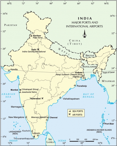
• India's trade with foreign countries is carried from the ports located along the coasts. 95 percent of the country's trade volume (68% in terms of value) is moved by sea.
Major Sea Ports of India
1. Kolkata Port
2. Haldi Port
3. Paradwip Port
4. Vishakhapatnam Port
5. Chennai Port
6. Tuticorin Port
7. Cochin Port
8. New Mangalore Port
9. Marmagao Port
10. Jawaharlal Nehru Port
11. Kandla Port
12. Port Blair Port
13. Mumbai Port
14. Ennore Port
To know more about the Major Seaports in India, please click on the link given below:
https://www.youtube.com/watch?v=JIaaAQ8tmTk
Major Sea Ports
• India has a long coastline of 7,516.6 km.
• India has 12 major and 187 medium and minor ports.
• These major ports handle 95 per cent of India's foreign trade.
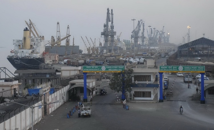
• Kandla in Kuchchh was the first port developed soon after independence to ease the volume of trade on the Mumbai port, in the wake of loss of Karachi port to Pakistan after the partition.
• Kandla is a tidal port.
• It caters to the convenient handling of exports and imports of highly productive granary and industrial belt stretching across the states of Jammu and Kashmir, Himachal Pradesh, Punjab, Haryana, Rajasthan and Gujarat.
• India Mumbai is the biggest port with a spacious natural and well-sheltered harbour.
• The Jawaharlal Nehru port was planned with a view to decongest the Mumbai port and serve as a hub port for this region.
• Marmagao port (Goa) is the premier iron ore exporting port of the country. This port accounts for about fifty per cent of India's iron ore export. New Mangalore port, located in Karnataka caters to the export of iron ore concentrates from Kudremukh mines. Kochi is the extreme south-western port, located at the entrance of a lagoon with a natural harbour.
• On the east coast, is the port of Tuticorin, in Tamil Nadu. This port has a natural harbour and rich hinterland. Thus, it has a flourishing trade handling of a large variety of cargoes to even our neighbouring countries like Sri Lanka, Maldives, etc. and the coastal regions of India.
• Chennai is one of the oldest artificial ports of the country. It is ranked next to Mumbai in terms of the volume of trade and cargo.
• Vishakhapatnam is the deepest landlocked and well-protected port. This port was, originally, conceived as an outlet for iron ore exports.
• Paradwip port located in Orissa, specializes in the export of iron ore.
• Kolkata is an inland riverine port. This port serves a very large and rich hinterland of Ganga- Brahmaputra basin. Being a tidal port, it requires constant dredge of Hoogly.
• Haldia port was developed as a subsidiary port, in order to relieve growing pressure on the Kolkata port.
AIRWAYS
• The air transport was nationalized in 1953.
• On the operational side, Indian airlines, alliance air (subsidiary of Indian airlines), private scheduled airlines and non- scheduled operators provide domestic air services.
• Air India provides international air services.
• Pawanhans helicopters ltd. Provides helicopter services to oil and natural gas commission in its off- shore operations, to inaccessible areas and difficult terrains like the north-eastern states and the interior parts of Jammu and Kashmir, Himachal Pradesh and Uttaranchal. Indian airlines operations also extend to the neighbouring countries of south and south-east asia and the middle east.
• It can cover very difficult terrains like high mountains, dreary deserts, dense forests and also long oceanic stretches with great ease.
SOME OF THE MAJOR AIRPORTS IN INDIA
• Delhi- Indira Gandhi International Airport
• Mumbai- Chattrapathi Shivaji International Airport
• Bengaluru- (Bangalore) International Airport
• Hyderabad- Rajiv Gandhi International Airport
• Chennai International Airport
• Kolkata- Netaji Subhash Chandra Bose International Airport
• Thiruvananthapuram – International Airport
• Amritsar - Sri Guru Ram Dass Jee International Airport
COMMUNICATION
• People all over the world have been using different means of communication.
• Personal communication and mass communication including television, radio, press, films, etc. are the major means of communication in the country.
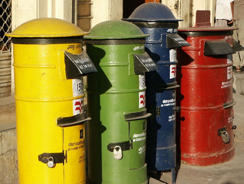
Indian Postal Service:
• The Indian postal network is the largest in the world.
• It handles parcels as well as personal written communications.
• Cards and envelopes are considered first-class mail and are airlifted between stations covering both land and air.
• The second-class mail includes book packets, registered newspapers and periodicals. They are carried by surface mail, covering land and water transport.
• To facilitate quick delivery of mails in large towns and cities, six mail channels have been introduced recently. They are called Rajdhani Channel, Metro Channel, Green Channel, Business Channel, Bulk Mail Channel and Periodical Channel.
![]()
To know more about the Latitudes and Longitudes of India, please click on the link given below:
https://www.youtube.com/watch?v=hRLpi6YoObY
Telephone:
• India has one of the largest telephone networks in Asia.
• In order to strengthen the flow of information from the grassroots to the higher level, the government has made special provision to extend twenty-four hours STD (Subscriber Trunk Dialing) facility to every village in the country.
• There is a uniform rate of STD facilities all over India. It has been made possible by integrating the development in space technology with communication technology.
Mobile Telephone:
• India is one of the fastest growing mobile network in the world.
• Mobile phones have changed the way Indians conducted business.
• Now even low income group people like vegetable vendors, plumbers and carpenters get better business because they are connected through mobile phones.
Mass Communication:
• Mass communication provides entertainment and creates awareness among people about various national programmes and policies.
• It includes radio, television, newspapers, magazines, books and films.
• All India Radio (Akashwani) broadcasts a variety of programmes in national, regional and local languages for various categories of people, spread over different parts of the country.
• Doordarshan, the national television channel of India, is one of the largest terrestrial networks in the world.
• It broadcasts a variety of programmes from entertainment, educational to sports, etc. for people of different age groups.
![]()
Newspapers:
• India publishes a large number of newspapers and periodicals annually.
• They are of different types depending upon their periodicity.
• Newspapers are published in about 100 languages and dialects.
• Largest number of newspapers published in the country are in Hindi, followed by English and Urdu.
Films:
• India is the largest producer of feature films in the world.
• It produces short films; video feature films and video short films.
• The central board of film certification is the authority to certify both Indian and foreign films.
INTERNATIONAL TRADE
• The exchange of goods among people, states and countries is referred to as trade.
• The market is the place where such exchanges take place.
• Trade between two countries is called international trade.
• It may take place through sea, air or land routes.
• Advancement of international trade of a country is an index to its economic prosperity.
• It is, therefore, considered the economic barometer for a country.
• Resources are unevenly distributed throughout the world. Thus, no country can survive without international trade.
• Import and export are the two main components of international trade.
• Export: Exports are the goods and services produced in one country and sold to another country.
• Import: Imports are foreign goods and services bought by a country.
• Balance of Trade: The difference between export and import of a country.
• When the value of exports is higher than value of imports then this is termed as favourable balance of trade.
• On the other hand, when the value of imports is higher than value of exports, then this is termed as unfavourable balance of trade.
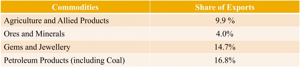
SHARE IN EXPORTS OF THE MAJOR INDIAN COMMODITIES IN THE YEAR 2010-11
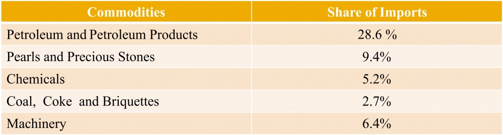
SHARE IN IMPORTS OF THE MAJOR INDIAN COMMODITIES IN THE YEAR 2010-11
International Trade:
(a) In the year 2010-11, the Bulk imports as a group registered a growth accounting for 28.2% of total imports.
(b) This group includes:
• Fertilizers – 3.4%
• Cereals – 14.3%
• Edible Oils – 17.4%
• Newsprint – 40.3%
(c) International trade has seen a tremendous change in the last fifteen years.
(d) Exchange of commodities and goods have been superseded by the exchange of information and knowledge.
(e) India has emerged as a software giant at the international level and it is earning large foreign exchange through the export of information technology.
TOURISM AS A TRADE:
(a) Tourism in India has grown largely over the last three decades.
(b) Foreign tourist's arrivals in the country witnessed an increase of 11.8 per cent during the year 2010 as against the year 2009, contributing Rs 64,889 crore of foreign exchange in 2010.
(c) 5.78 million foreign tourists visited India in 2010.
(d) More than 15 million people are directly engaged in the tourism industry.
(e) Tourism also promotes national integration, provides support to local handicrafts and cultural recreations.
(f) It also helps in the development of international understanding about our culture and heritage.
(g) Foreign tourists visit India for heritage tourism, eco tourism, adventure tourism, cultural tourism, medical tourism and business tourism.
(h) There is a vast potential for development of tourism in all parts of the country.
(i) Efforts are being made to promote different types of tourism for this upcoming industry.

-----x-----X-----x-----