CONSTITUTION DAY OF INDIA
_0_o.jpg)
_0_o.jpg)
_1_o.jpg)
Q1. Explain the divisions of the Himalayas on the basis of regions from west to east.
Ans: On the basis of regions from west to east and the rivers flowing, the great Himalayas have been divided into four divisions:
(a) Punjab Himalayas: This part lies between the Indus and Sutlej. They are also known as Kashmir Himalaya and Himachal Himalaya.
(b) Kumaon Himalayas: This part lies between Sutlej and Kali rivers.
(c) Nepal Himalayas: This part lies between the Kali and Tista rivers.
(d) Assam Himalayas: This part lies between the Tista and Dihang rivers.
Q2. Write short notes on the following:
(a) The Indian Desert (b) The Central Highlands (c) The Island groups of India
Ans:
(a) The Indian Desert: The Indian desert lies towards the western margins of the Aravali Hills. This region gets scanty rainfall which is less than 150 mm in a year. Hence they climate is arid and vegetation is scanty. Luni is the only large river but some streams appear during rainy season. Crescent-shaped dunes (barchans) abound in this area.
(b) The Central Highlands: The Central Highlands lies to the north of the Narmada River. Central Highlands is broadly divided into two: The Malwa Plateau and the Chhotanagpur plateau. It covers the major portion of the Malwa plateau. The rivers in this region flow from southwest to northeast; which indicates the slope of this region. It is wider in the west and narrower in the east. Bundelkhand and Baghelkhand mark the eastward extension of this plateau.
The plateau further extends eastwards into the Chhotanagpur plateau, this area is very rich in minerals.
(c) The Island groups of India: The Lakshadweep Islands are in the Arabian Sea. Its area is 32 sq km. The administrative headquarters of Lakshadweep is at Kavaratti Island. This group of islands is rich in terms of biodiversity.
The Andaman and Nicobar Islands are bigger in size and has more number of islands. Its area is 8249 sq km. This group of islands can be divided into two groups. The Andaman is in the north and the Nicobar is in the south. These islands too have rich biodiversity.
Q3. What are tectonic plates? Name three types of stress build with the plates.
Ans: The crust of the earth is not in the form of a continuous plate rather in the form of broken pieces. These pieces of the earth's crust are called tectonic plates. Broadly, there are seven major plates: African Plate, Antarctic Plate, Eurasian Plate, Indo-Australian Plate, North American Plate, Pacific Plate and South American Plate.
Stress build with the plates leads to Folding, Faulting and Volcanic Activities.
Q4. Which part of India is called Purvachal? Mention few characteristics of Purvachal.
Ans: The Brahmaputra River marks the eastern boundary of the Himalayas. Beyond the Dihang gorge, the Himalayas bend sharply towards south and form the Eastern hills or The Purvachal.
Following are the characteristics of Purvachal:
(a) These hills run through the north eastern states of India.
(b) They are mostly composed of sandstones (i.e. Sedimentary rocks).
(c) These hills are covered with dense forest.
(d) These hills are composed of the Patkai Hills, Naga Hills, Manipuri Hills and Mizo Hills.
Q5. Explain the three major divisions of the Himalayas from north to south.
Ans: Three major divisions of the Himalayas from north to south are:
(a) The Great or Inner Himalaya or Himadri:
• This is the northernmost range and is also known as 'Himadri'.
• This is the most continuous range.
• The average height of peaks in this range is 6,000 meters.
• All the prominent Himalayan peaks are in this range.
• The folds of the Great Himalayas are irregular in nature.
• Because of the lofty heights, the peaks of this range are perennially covered with snow.
• Famous glaciers like the Siachen Glacier, the Gangotri and Yamunotri, etc.
(b) The Lesser Himalaya or Himachal:
• This range lies towards the south of the Great Himalayas.
• The altitude of peaks in this range varies from 3,700 to 4,500 meter.
• Average width of this range is 50 km.
• The most important mountain range here is the Pir Panjal mountain range and it is the longest range. Dhaula Dhar and Mahabharat are also important ranges of lesser Himalayas.
• All great valleys like Kashmir Valley, Kangra Valley, Kullu Valley are present here.
• This region is also known as for its hill stations (for e.g. Kullu,-Manali, Kufri, Shimla, Mussoorie, Nanital, etc.).
(c) The Outer Himalayas or The Shiwaliks:
• The altitude varies between 900 and 1100 meters in this range.
• The width varies between 10 to 50 km.
• These ranges are composed of unconsolidated sediments brought down by the rivers.
The longitudinal valleys lying between the Himachal and Shiwaliks are called 'Dun'. E.g. The dun of Dehra, it is the biggest with a length of 35 km and width of 25 km.
Q6. Distinguish between Western Coastal Plains and Eastern Coastal Plains.
Ans:

Q7. Distinguish between Western Ghats and Eastern Ghats.
Ans:
. eastern & western ghats_1_o.jpg)
Q8. Explain the Northern Plains of India with its divisions.
Ans: The northern plain of India is formed by three river systems, i.e. the Indus, the Ganga and the Brahmaputra; along with their tributaries. This plain is composed of alluvial soil which has been deposited over millions of years. The total area of the northern plain is about 7 lakh square kilometer. It is about 2400 km long. Width is about 240 to 320 km. Northern plains are most densely populated areas of the country. The plains are very fertile and agriculturally very productive.
The northern plain is divided into three sections, i.e. the Punjab Plains, the Ganga Plains and the Brahmaputra Plains.
(a) Punjab Plains: The Punjab plains form the western part of the northern plain. This is formed by the Indus and its tributaries; like Jhelum, Chenab, Ravi, Beas and Sutlej. A major portion of these plains is in Pakistan. Doabs are found in Punjab plains.
(b) Ganga Plains: This plain extends between Ghaggar and Tista rivers. The northern states, Haryana, Delhi, UP, Bihar, part of Jharkhand and West Bengal in the east lie in the Ganga plains.
(c) Brahmaputra Plains: This plain forms the eastern part of the northern plain and lies in Assam.
Based on the relief features; the northern plain can be divided into four regions, viz. Bhabar, Terai, Bhangar and Khadar.
(a) Bhabar: After descending from the mountains, the rivers deposit pebbles in a narrow belt. The width of this belt is about 8 to 16 kms. It lies parallel to the Shiwaliks. Bhabhar is the gently-sloping coarse alluvial zone below the Siwalik Hills (outermost foothills of Himalayas) where streams disappear into permeable sediments. The underground water level is deep in this region.
(b) Terai: The terai region lies towards south of the bhabar belt. In this region, the streams reappear and make a wet, swampy and marshy region. This region was full of forest and wildlife but after partition all this area was cleared and was converted into agricultural land for the settlement of the migrants.
(c) Bhangar: Bhangar is the largest part of the northern plain and is composed of the oldest alluvial soil. They lie above the flood plains. They resemble terraces. The soil of this region is locally known as kankar and is composed of calcareous deposits.
(d) Khadar: The floodplains formed by younger alluvium are called Khadar. The soil in this region is renewed every year and is highly fertile. This region is very suitable for intensive agricultural activities.
Q9. Contrast the relief of the Himalayan region with that of the Peninsular Plateau.
Ans: The following compares and contrasts between the reliefs of the Himalayan region with that of the Peninsular plateau:
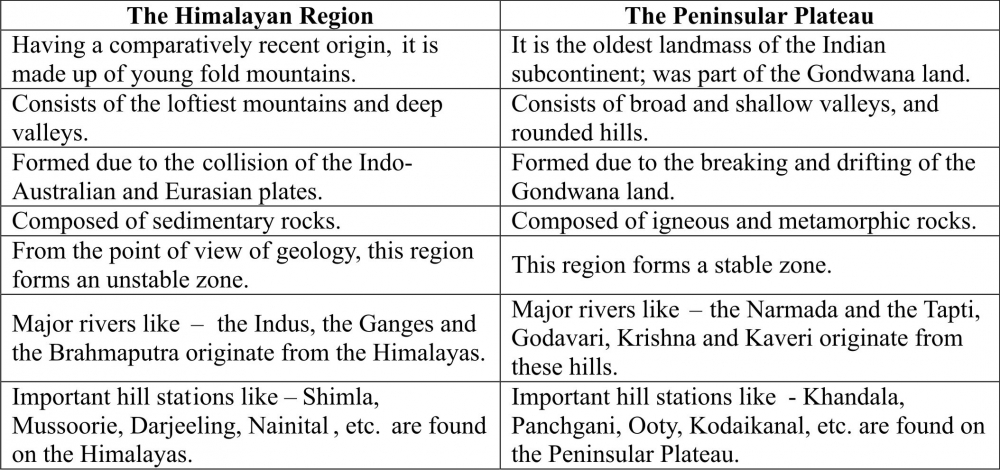
Q10. Map Work: 2016-17_0_o.jpg)
-----x-----X-----x-----
Very Short Answer Questions
Q1. Define: (a) Endogenic Forces (b) Exogenic Forces (c) Lithospheric Plates
Ans 1:
(a) Endogenic Forces: Forces which are working in the interior of the earth leading to earth movements, earthquakes and volcanic eruption are known as endogenic forces.
(b) Exogenic Forces: Forces which are working on the surface of the earth leading to the erosional and depotional features of wind, water and ice are known as exogenic forces.
(c) Lithospheric Plates: The crust of the earth is broken into a number of large and small plates known as the lithospheric plates.
Q2. What is volcano? What are its types?
Ans 2: Natural openings in the earth's crust through which molten materials, rocks, ashes, gases, etc are thrown out are called 'Volcanoes'. Volcanoes are classified into three types:
(a) Active Volcanoes: These volcanoes erupt frequently and give out gases, ash, lava, etc. e.g. Mt. Etna in Italy.
(b) Dormant Volcanoes: These are also known as 'Sleeping Volcanoes'. They erupt after a very long time. E.g. Mt. Vesuvius in Italy.
(c) Extinct Volcanoes: These are also known as 'Dead Volcanoes'. They have been inactive since a very long time. E.g. Mt. Kilimanjaro in East Africa.
Q3. What do you mean by 'Focus' and 'Epicentre'?
Ans 3: Focus: The point of origin of an earthquake is called its Focus.
Epicenter: The point directly/vertically above the focus on the earth's surface is known as Epicenter.
Q4. What are meanders?
Ans 4: Curves and large bends or loops formed by rivers in the plains are known as meanders.
Q5. Define the term 'Aggradation'.
Ans 5: The process of depositing the eroded material is called aggradation.
Short Answer Questions
Q6. How does the process of gradation creates various landforms?
Ans 6: The surface of the earth is continuously undergoing changes. Running water, moving ice, wind and waves are the main agents of gradation which continuously wear down the land surface and carry the broken fragments which are deposited in the low lying areas.
The process of reduction of height of landform is called 'degradation'. The process of depositing the eroded material is called 'aggradation'. Aggradation and degradation are the two main ways which as continuously at work creating different landforms on the earth surface.
Q7. What do you mean by erosion? What are the main agents of erosion?
Ans 7: The removal of outer layer of rocks in the natural environment is called erosion. The main agents of erosion are water, wind and ice.
Long Answer Questions
Q8. Give a detailed account of the features formed by Wind, Waves and Ice.
Ans 8: The features formed by wind are as follows:
(a) Mushroom Rocks: In deserts you can see rocks in the shape of a mushroom, commonly called mushroom rocks. Winds erode the lower section of the rock more than the upper part. Therefore, such rocks have narrower base and wider top.
(b) Sand Dunes: When the wind blows, it lifts and transports sand from one place to another. When it stops blowing the sand falls and gets deposited in low hill – like structures. These are called sand dunes.
(c) Barkhan: A crescent shaped sand dune is called a barkhan.
(d) Loess: When the grains of sand are very fine and light, the wind can carry it over very long distances. When such sand is deposited in large areas, it is called loess.
The features formed by sea waves in the coastal areas are as follows:
(a) Sea Caves: Sea waves continuously strike at the rocks. Cracks develop. Over time they become larger and wider. Thus, hollow like caves are formed on the rocks. They are called sea caves.
(b) Sea Arches: When these cavities become bigger and bigger only the roof of the caves remain, thus forming sea arches.
(c) Stacks: Further, erosion breaks the roof and only walls are left. These walls like features are called stacks.
(d) Sea Cliff: The steep rocky coast rising almost vertically above sea water is called sea cliff.
(e) Beaches: The sea waves deposit sediments along the shores forming beaches.
The features formed by ice are as follows:
(a) Lakes: Glaciers carve out deep hollows. As the ice melts they get filled up with water and become beautiful lakes in the mountains.
(b) U-Shaped Valley: Formation of "U" shaped valleys, which are deep and have steep sides.
(c) Glacial Moraines: The material carried by the glacier such as rocks big and small, sand and silt gets deposited. These deposits form glacial moraines.
Q9. What are tectonic plates? Why do they cause tremors?
Ans 9: The crust of the earth is not in the form of a continuous plate rather in the form of broken pieces. These pieces of the earth's crust are called tectonic plates. Broadly, there are seven major plates: African Plate, Antarctic Plate, Eurasian Plate, Indo-Australian Plate, North American Plate, Pacific Plate and South American Plate.
According to the theory of continental drift, these tectonic plates are constantly moving. When these plates collide with each other, tremors or earthquakes are caused. Sudden vibration caused by the movement of lithospheric plates is called earthquake.
Q10. How are features formed by a river different from that formed by a river of Ice?
Ans 10: The features formed by a river are as follows:
(a) 'I' & 'V' shaped valley (b) Gorges or Canyons (deep valleys)
(c) Waterfalls, etc. (d) Meanders (curves & large bends or loops)
(e) Oxbow Lakes (f) Flood Plains
(g) Levees (slightly raised river banks) (h) Delta
(i) River breakup into various streams called 'distributaries'.
The features formed by ice are as follows:
(a) ''U' shaped valley (b) Lakes (c) Glacial Moraines
The course of a river is very large in compression to that of a glacier (river of ice). A river flows from mountains, plains and forms various features before submerging into the sea. Whereas, course of a glacier is confined to the mountains only. River contains water which is in liquid form and Glaciers contain ice which is in solid/semi-liquid for, due to which the features formed are different.
Q11. Why are deltas so fertile?
Ans: A river when approaches towards its last stage of its course before submerging into the seas and oceans becomes very slow. Due to the load of sediments the river is carrying and because of the flat land, it is forced to deposit the sediments near the mouth. The river starts breaking into number of small streams known distributaries. The network of distributaries form a triangular shaped feature called delta. These deltas are most fertile areas in the course of a river. The deposition of sediments in the deltas is a continuous process making these deltas the most fertile areas. Sunderbans delta formed by the Ganga – Brahmputra river is the biggest delta and also is very fertile.
Q12. Name the erosional and depositional features found in coastal areas Explain how they are formed.
Ans: The erosional features formed by sea waves in the coastal areas are as follows:
(a) Sea Caves: Sea waves continuously strike at the rocks. Cracks develop. Over time they become larger and wider. Thus, hollow like caves are formed on the rocks. They are called sea caves.
(b) Sea Arches: When these cavities become bigger and bigger only the roof of the caves remain, thus forming sea arches.
(c) Stacks: Further, erosion breaks the roof and only walls are left. These walls like features are called stacks.
(d) Sea Cliff: The steep rocky coast rising almost vertically above sea water is called sea cliff.
The depotional features formed by sea waves in the coastal areas are as follows: -
(a) Beaches: The sea waves deposit sediments along the shores forming beaches.
Give Reasons
Q13. Wind action is prominent in desert area. Why?
Ans 13: Wind action can be best seen in the desert areas. Features like sand dunes, Mashroom rocks, etc. are formed by the wind action. Wind acts as an agent of erosion and deposition which leads to the formations of different features.
In the deserts we don't find lot of vegetation due to which the wind flows without any disturbance or obstruction. Also, because of the lack of vegetation there is no moisture content in the soil and it is not able to hold itself and becomes very loose (sand). In a wide area with barren land the wind blows with great velocity creating new features specially in the deserts.
Q14. Meanders are formed by the rivers in plains. Why?
Ans 14: Rivers are the most important agents of degradation. As the river flows from the mountainous regions, it has great erosive power. Speed and force of water is great, during this course river does lots of erosional work. As the river enters into the plains, all of sudden the speed of flow of water is reduced to a greater extent and the river widens. In the plains river forms curves and large bends or loops called the meanders
-----x-----X-----x-----
Very Short Answer Questions
Q1. Define: (a) Crust (b) Mantle (c) Core (d) Rocks (e) Ore (f) Lava (g) Magma
Ans 1:
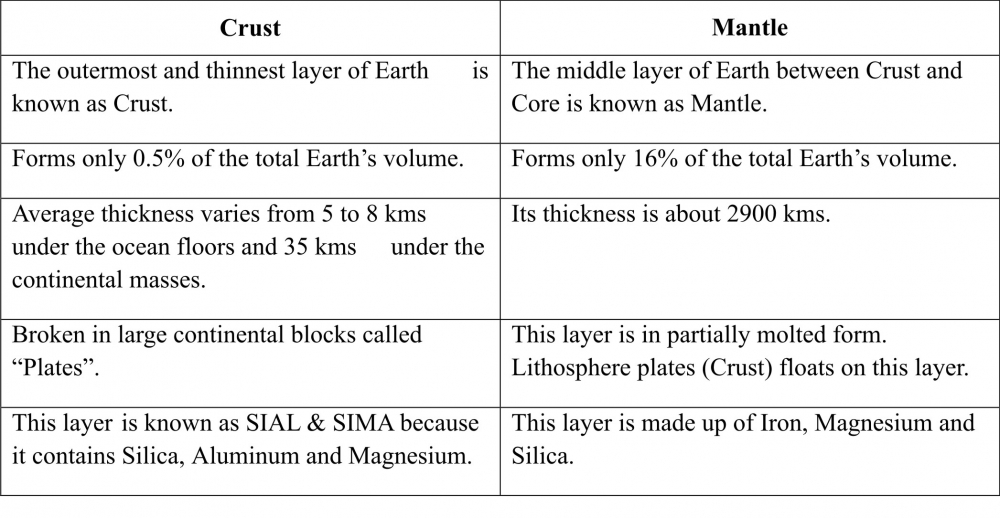
(a) Crust: The outermost and thinnest layer of Earth is known as Crust.
(b) Mantle: The middle layer of Earth between Crust and Core is known as Mantle.
(c) Core: The innermost layer, forming the metallic centre of the Earth is known as Core.
(d) Rocks: All solid materials of the earth's crust, whether hard or soft, that make up the earth's crust are called Rocks.
(e) Ore: A rock in which a particular mineral is found in large percentage is called an ore.
(f) Lava: The red molted rock material erupting from the earth in the form of a volcano is known as Lava.
(g) Magma: The molted rock material inside the earth is known as Magma.
Q2. What are minerals?
Ans 2: Rocks form the solid mass of the earth's crust. The rock forming materials are known as "Minerals".
Long Answer Questions
Q3. Explain the classification and characteristics of rocks.
Ans 3: Rocks have different colours, mineral composition, hardness, etc. and according to their formation, rocks can be classified into three categories: -
1. Igneous Rocks
2. Sedimentary Rocks
3. Metamorphic Rocks
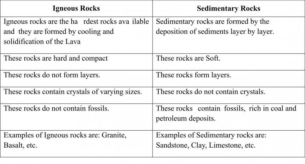
1. Igneous Rocks: The word 'Igneous' is derived from Latin word "Ignis" meaning "Fire". This is also called Primary rock. These are the first rocks to be formed and are known as the ancestors of all the rocks. Igneous rocks are the hardest rocks available and it is formed by cooling and solidification of the Lava coming out from the interior of the Earth's interior. E.g. Granite, Basalt, etc. Igneous rocks are of two types:
(a) Solidification of rocks below the earth's surface is known "Intrusive rocks".
(b) The magma which reaches the earth's surface and gets solidified is known as "Extrusive Rocks".
Features of igneous rocks are: -
1. These rocks do not form layers.
2. They contain crystals of varying sizes.
3. They do not contain fossils.
2. Sedimentary Rocks: The word 'Sedimentary' is derived from Latin word "Sedimentum" meaning "Settle Down". Particles that form a sedimentary rock by accumulating are called sediments. Before being deposited, sediment was formed by weathering and erosion in a source area, and then transported to the place of deposition by water, wind, ice, mass movement or glaciers which are called agents of denudation.
Features of Sedimentary rocks are: -
1. They are layered, called stratified rocks.
2. They do not contains crystals.
3. They contain fossils embedded in them.
4. They are rich in coal and petroleum deposits.
5. Examples of Sedimentary rocks are: - Sandstone, Clay, Limestone, etc.
6. 70% of the total earth's surface is dominated with these rocks.
3. Metamorphic Rocks: The word 'Metamorphic' is derived from Greek word "Metamorphose" meaning "Change of Form". When igneous or sedimentary rocks are subjected to great heat or pressure, the original character and appearance of the rock change into a new form. Thus, these rocks are formed by the alteration of other rocks. E.g. graphite, slate, Marble, etc.
Features of metamorphic rocks are: -
1. They are hard in nature.
2. Valuable minerals like gold & silver are found in these rocks.
3. They do not contain fossils.
4. Takes a long time to form.
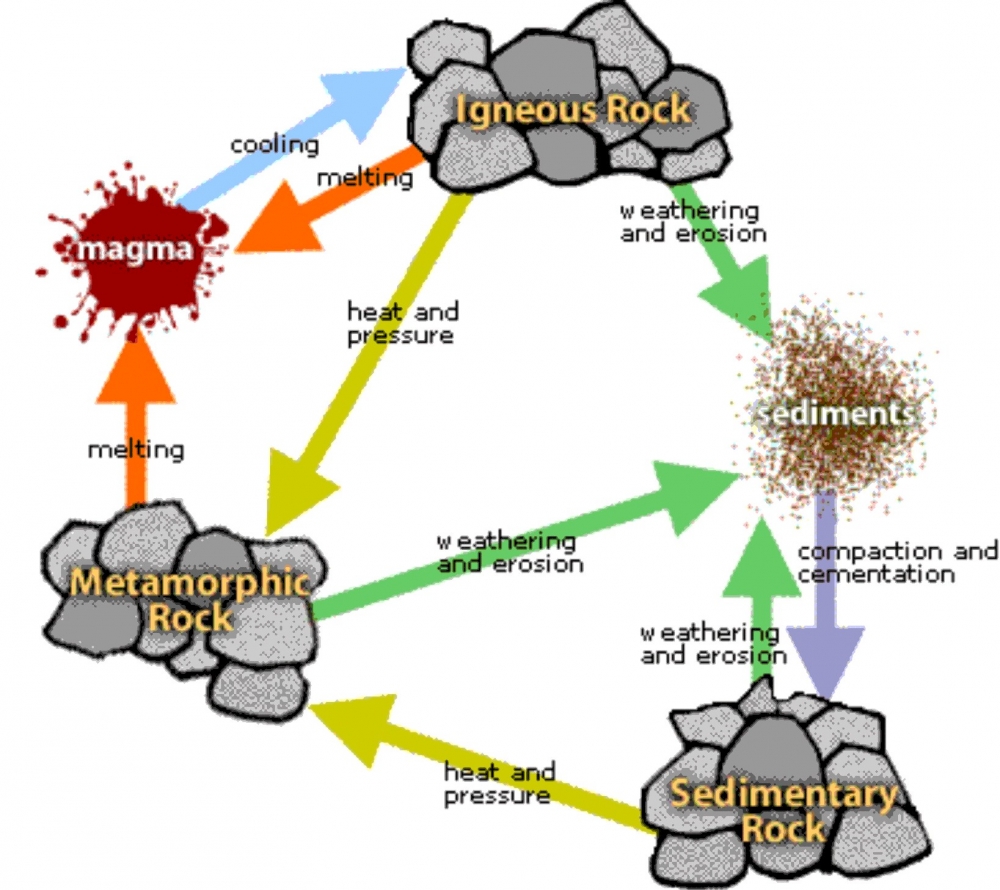
Q4. Describe the rock cycle with a suitable diagram.
Ans 4: Rocks undergo a cycle of transformation. Change into sedimentary rock or into metamorphic rock. Sedimentary rock can change into metamorphic rock or into igneous rock. Metamorphic rock can change into igneous or sedimentary rock. Hence, this cycle of change from one type of rock to another is called 'rock cycle'.
Rocks are continually being formed, destroyed and reformed due to changing weather conditions and forces of nature (eg. Wind, river, glaciers, earth movements, etc.)
Q5. What is the usefulness of rocks and minerals to us?
Ans 5: Rocks and minerals are very useful to mankind. Following are the usefulness of rocks and minerals:
1. Different vegetations.
2. Different types of minerals for industries.
3. Different rock materials for construction purposes.
4. Different chemicals for medicine and fertilizer industries.
5. Source of fuels like coal and crude oil.
6. Source of precious stones like, gold, silver, etc.
Q6. Why do we get both fossils and fossil fuels primarily in the sedimentary rocks?
Ans 6: Fossils are the preserved remains or traces of animals, plants, and other organisms from the remote past. Fossil fuels are fuels formed by natural processes such as decomposition of buried dead plants and animals.
Amongst the three major types of rock, fossils are most commonly found in sedimentary rock. Unlike most igneous and metamorphic rocks, sedimentary rocks form at temperatures and pressures that do not destroy fossil remnants. Sedimentary rocks are formed by the deposition of sediments layer by layer making it easy to contain fossils and fossil fuels. Sedimentary rocks are soft rocks, thus it dose not destroy the fossils and in a longer run we get the fossil fuels like coal and petroleum products, which are very important for human life.
Q7. All the minerals are exhaustible. What would happen if coal, petroleum and few other minerals get exhausted completely? What effect it would have on our life?
Ans 7: Coal, Petroleum and other minerals are non-renewable resources, they get exhausted when put to use. It takes millions of years to form these minerals. In todays world we cannot imagine human life without coal and petroleum products. coal and petroleum products are used in household sector, industrial sector, electrical sector, transportation sector, etc. making our life easy. But the usage of these products are increasing very fast day-by-day and if we are not serious very soon these minerals will be exhausted.
Human life will be effected very badly if coal and petroleum products get exhausted completely. If such a situation occurs we won't get proper electricity, transportation will be a great problem, all household items will become very costly, Food items will not be available on time, in short the survival of human life will be very difficult.
Q8. Differentiate between: (a) Crust and Mantle (b) Igneous and Sedimentary Rocks
Ans 8:
(a) Crust and Mantle
(b) Igneous and Sedimentary Rocks
-----x-----X-----x-----
Very Short Answer Questions
Q1. Define the term Environment.
Ans: The immediate natural surroundings of man is called environment. E.g.: Plants, Air, Water, Landforms, Wildlife, etc.......
The word Environment has been derived from a French word "Environner" which means "Neighborhood".
Q2. What do you mean by Ecology?
Ans: The Science with studies the relationship between living and non-living environment is termed as Ecology.
Q3. Why is an ecosystem considered as the central feature of ecology?
Ans: The Interrelation between plants and animals in the natural environment is called Ecosystem.
The Science with studies the relationship between living and non-living environment is termed as Ecology. Thus, Ecology helps us to understand how a large variety of life forms depend upon the non living things and are influenced by their interaction with their environment.
Short Answer Questions
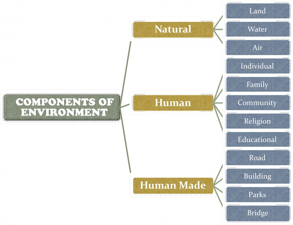
Q4. What are the different components of the environment?
Ans: Different components of the environment are:
(a) Natural Environment (b) Human Environment (c) Human Made Environment
Q5. Why is lithosphere important?
Ans: The hard outermost solid layer of the earth which is made up of rock material is called crust. This solid crust of the earth is called Lithosphere. On this lithosphere we find different landforms such as the mountains, plateaus and plains. It provides us land where we live and also, it is a great source of vegetation, wildlife and mineral wealth. The crust is covered by a thin layer of soil which is of great importance for life. Lithosphere provides us the three basic necessities of life, i.e. Food, Cloth and Shelter.
Q6. Define atmosphere. Why is it important?
Ans: The layer of air around us is called Atmosphere. Following is the importance of atmosphere: -
(a) It gives us life giving gases like oxygen for breathing of animal kingdom and carbon dioxide is inhaled by plant kingdom.
(b) It has Ozone layer which protects us from the harmful ultraviolet rays of the sun.
(c) There are tiny dust particles in the atmosphere which helps in the formation of the rain droplets.
(d) It acts as a blanket which prevents the earth from becoming too hot during day and too cold during night.
(e) It protects us from falling meteors and other cosmic dusts. They burn when coming in contact with the atmosphere.
(f) Presence of gases, dust particles and water vapours lend colours to the sky.
Long Answer Questions
Q7. What efforts must be made to protect the environment?
Ans: Following are some of the efforts which must be made to protect the environment: -
(a) Encourage / motivate others to be more sensitive towards environment.
(b) Plant more trees (Aforestation)
(c) Protest / control Deforestation.
(d) Reduce, Reuse, Recycle.
(e) Conserve every drop of water.
(f) Cut Energy Consumption.
(g) Support Climate Change Initiatives. E.g. reducing CO2 emissions
(h) Buy Energy-efficient and Eco-friendly electrical appliances.
(i) Drive Less and Drive Smart.
Q8. "The environment gives us life and protection in various ways and maintain balance on its own". Enlist the human activities that cause imbalance in the environment.
Ans: Following are few of the human activities that have caused imbalance in the environment: -
(a) Deforestation
(b) Overgrazing
(c) Pollution (Air, Water, Land and Noise)
(d) Casual and careless attitude towards the environment.
(e) Destroying the animal habitats
(f) Hunting
(g) Urbanization
(h) Industrialization
(i) Overpopulation
Q9. Biosphere is the right combination of the three sphere or realms – Atmosphere, Lithosphere and Hydrosphere. Do you think that the biosphere can exist in the absence of anyone of them? Give reason for your answer.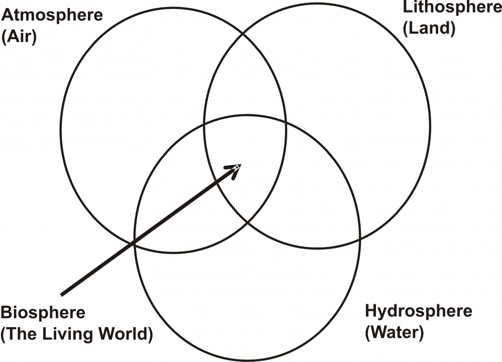
Ans. Plant and animal kingdom together make Biosphere or the living worlds. It is a narrow zone of the Earth where Air (Atmosphere), Water (Hydrosphere) and Land (Lithosphere) interact with each other to support life.
There will be no existence of biosphere incase any one of the three sphere or realms is missing.
For example, to survive a human being requires oxygen to breathe (i.e Atmosphere), food cloth and shelter, the three basic necessities of life are provided by the Lithosphere and without water there is no survival.
Thus, we can understand that all the three spheres are equally important for the existence of life or the Biosphere.
Q10. We, the humans are an integral part of the environment but we are a bit different from other creatures. How? What makes us different?
Ans. There are a number of different things that make humans different from other creatures. Human beings adapt themselves to the natural environment by making modifications in their food, cloth and shelter. They also modify their natural environment to suit their social, biological, cultural and economic needs.
The early human beings slept on trees and caves, they used to roam around in search of food as that of other creatures but with the passage of time, with the help of their mind, thinking skills, ability, knowledge, hard work, etc. they have changed themselves drastically. Now, the modern man is far more organized, skilled, well mannered and cultured. They live in houses, eat cooked food, travel from one place to another by various means of transportation, etc.
The biggest difference is that the humans have the ability to create but in case of animals or other creatures, they cannot create. They must depend on whatever is available around them to survive.
-----x-----X-----x-----