Nirman Care - an educational blog

Class VIII: Chapter 6 - Human Resource

Important points to remember:

1. Demography: The study of population is known as Demography.

2. Census: The official collection of population data by all means is known as Census. This is conducted once in ten years. Currently, we are following 2011 census. In 1872, first population census of India was conducted. The Census of India 2011 is the fifteenth census starting from1872 and the seventh since independence.

3. Human beings use their knowledge and skill to convert natural resource into more valuable goods.

4. It is people with their demands and abilities that turn them into 'resources'.

5. Human resources like other resources are not equally distributed over the world. They differ in their educational levels, age and sex.

6. More than 90% of the world population lives in the continents of the Northern Hemisphere (Continents found in the northern hemisphere include Europe, Caribbean, North America and Central America. Other continents such Asia, Africa and South America), where as only 10% of the population resides in the continents of the Southern Hemisphere (Continents found entirely in the southern hemisphere are Antarctica and Australia. Other continents have parts in this region, and they include Africa, Asia and South America).


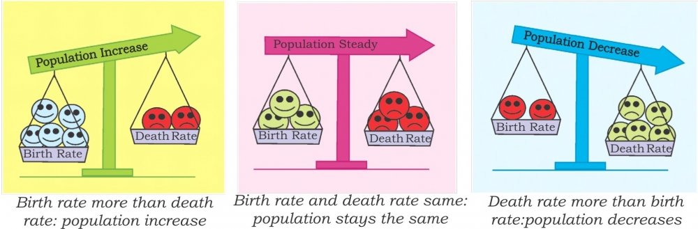
7. Birth Rate: Births are usually measured using the birth rate i.e. the number of live births per 1,000 people.they include Africa, Asia and South America).5. Human resources like other resources are not equally distributed over the world. They differ in their educational levels, age and sex.

8. Death Rate: Deaths are usually measured using the death rate i.e. the number of deaths per 1,000 people.

9. Migrations is the movement of people in and out of an area. Emigrants are people who leave a country; Immigrants are those who arrive in a country.

10. Natural Growth Rate: Births and deaths are the natural causes of population change. The difference between the birth rate and the death rate of a country is called the natural growth rate.

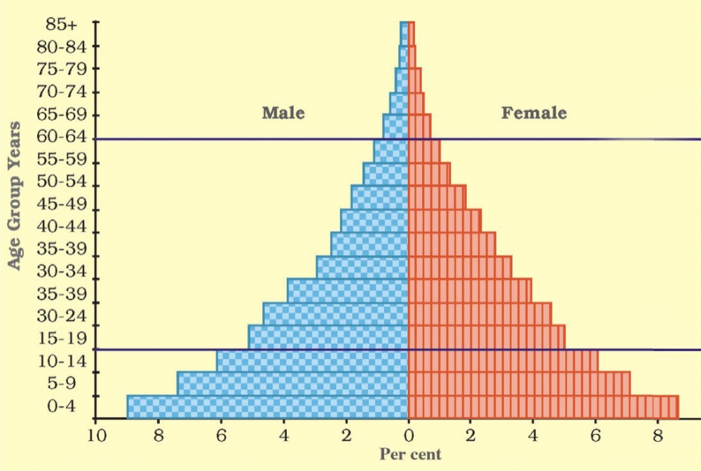
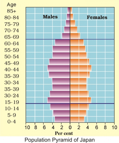
11. Population Pyramid is a graphical representation of the age, sex composition of the population.


Study of Population includes:

  • Population Size and Distribution.
  • Population Growth and Process of Population Change.
  • Characteristics or qualities of the population.


FACTORS AFFECTING DISTRIBUTION OF POPULATION


GEOGRAPHICAL FACTORS:

1. Topography: People always prefer to live on plains rather than mountains and plateaus because these areas are suitable for farming, manufacturing and service activities. The Ganga plains are the most densely populated areas of the world while mountains like Andes, Alps and Himalayas are sparsely populated.

2. Climate: People usually avoid extreme climates that are very hot or very cold like Sahara desert, polar regions of Russia, Canada and Antarctica.

3. Soil: Fertile soils provide suitable land for agriculture. Fertile plains such as Ganga and Brahmaputra in India, Hwang-He, Chang Jiang in China and the Nile in Egypt are densely populated.

4. Water: People prefer to live in the areas where fresh water is easily available. The river valleys of the world are densely populated while deserts have spare population.
Minerals: Areas with mineral deposits are more populated. Diamond mines of South Africa and discovery of oil in the Middle east lead to settling of people in these areas.


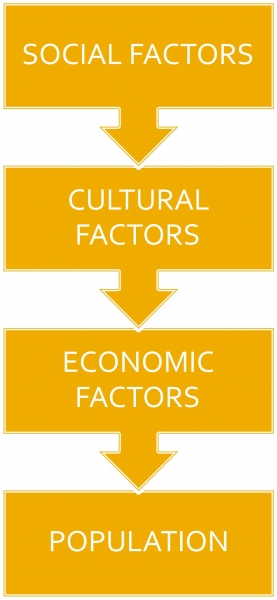
Social, Cultural and Economic Factors:

1. Social: Areas of better housing, education and health facilities are more densely populated e.g., Pune.

2. Cultural: Places with religion or cultural significance attract people. Varanasi, Jerusalem and Vatican city are some examples.

3. Economic: Industrial areas provide employment opportunities. Large number of people are attracted to these areas. Osaka in Japan and Mumbai in India are two densely populated areas.


POPULATION CHANGE
1. The population change refers to change in the number of people during a specific time. The world population has not been stable, it keeps on changing from time to time. The changes occur due to change in the number of births and deaths.

2. Birth Rate: Births are usually measured using the birth rate i.e. the number of live births per 1,000 people.

3. Death Rate: Deaths are usually measured using the death rate i.e. the number of deaths per 1,000 people.

4. A migration is the movement of people in and out of an area. Out-migration or Emigrants are people who leave a country & In-migration or Immigrants are those who arrive in a country.

5. Natural Growth Rate: Births and deaths are the natural causes of population change. The difference between the birth rate and the death rate of a country is called the natural growth rate. The population increase in the world is mainly due to rapid increase in natural growth rate.


PATTERNS OF POPULATION CHANGE
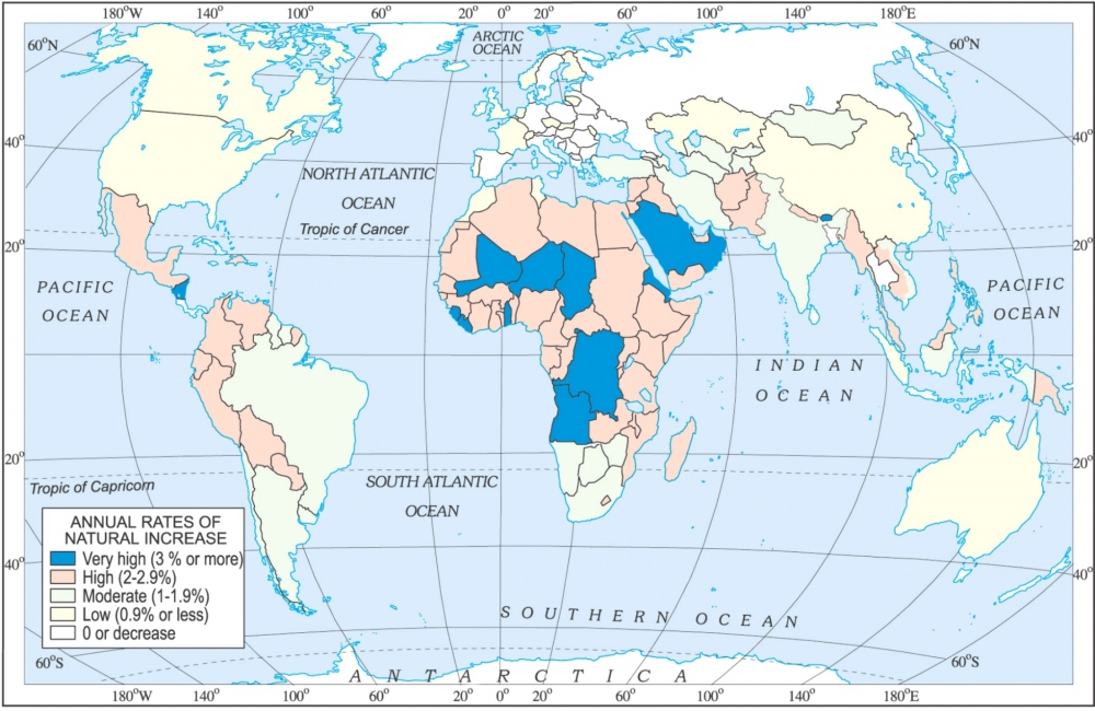
Rates of population growth vary from country to country. Some countries like Kenya have high population growth rates. They had both high birth rates and death rates. In other countries like United Kingdom, population growth is slowing because of both low death and low birth rates.
Now, with improving health care, death rates have fallen, but birth rates still remain high leading to high growth rates.


 DISTRIBUTION OF POPULATION

The way in which people are spread across the earth surface is known as the pattern of population distribution. Sixty per cent of the world's people stay in just 10 countries. All of them have more than a 100 million people.


DENSITY OF POPULATION

Population density is the number of people living in a unit area of the earth's surface. It is normally expressed as per square km. The average density of population in the whole world is 51 persons per square km.


COMPOSITION OF POPULATION
1. The structure of population is known as the Composition of Population.
2. It helps us to understand the number of males and females, rural and urban population, literate and illiterates, working and non-working population, income and health status.
3. An interesting way of studying the population composition of a country is by looking at the population pyramid, also called an age-sex pyramid. It helps us to know the population under different age groups (i.e. 0 – 15, 15 – 59 and 60 & above). It also shows the number of males and females under each group.


-----x-----X-----x-----


Class VII: Chapter 6 - Natural Vegetation and Wildlife

Meaning of Natural Vegetation: Natural vegetation refers to a plant community which has grown naturally without human aid and has been left undisturbed by humans for a long time.

Thus, cultivated crops and fruits, orchards form part of vegetation but not natural vegetation.

The type and thickness of natural vegetation varies from place to place because of the variation in these factors. Natural vegetation is generally classified in to three broad categories as follows:

(a) Forests: Which grow where temperature and rainfall are plentiful to support a tree cover. Depending upon these factors, dense and open forests are grown.
(b) Grasslands: Which grow in the region of moderate rain.
(c) Desert Shrubs: Thorny shrubs and scrubs grow in the dry


Factors affecting the natural vegetation and wildlife:

1. Rainfall & Temperature
2. Relief
3. Soil & its fertility
4. Slope of land
5. Sunshine
6. Drainage


Types of Natural Vegetations:


FORESTS

Tropical Rainforests:
These forests are also called Tropical Evergreen.

Location:

  • Forests found near the Equator (10° North to 10° South) in Amazon & Zaire Basin and Southeast Asia.

Climate:

  • These regions are hot and receive heavy rainfall throughout the year.

Characteristics:

  • As there is no particular dry season, the trees do not shed their leaves altogether. This is the reason they are called evergreen.
  • Maximum varieties of trees are found. Trees are tall with large trunks.
  • The thick canopies of the closely spaced trees do not allow the sunlight to penetrate inside the forest even in the day time. Thus, grass is not found in these forests.
  • Hardwood trees like rosewood, teak, sal, ebony, and mahogany are the common trees found here.
  • Here the population found is very less. Due to dense forests commercial exploitation of these forests has not be possible, making them economically backward.

Wildlife:

  • Large variety and most colourful animals are found here.
  • Monkey, Ape, Birds, Hippopotamus, snake, python, Frog, Crocodile, etc. Anaconda, world's largest snake is also found in these areas.


Tropical Deciduous Forests:
These forests are also called Monsoon Forests.

Location:

  • Forests found in large part of India, Northern Australia and in Central America.

Climate:

  • These regions are warm and receive rainfall less than 200 cms.

Characteristics:

  • These regions experience seasonal changes. Trees shed their leaves in the dry season to conserve water.
  • Trees like sandalwood, teak, sal, ebony, bamboo, etc. are the common trees found here.
  • Forests are not very dense thus; commercial exploitation of these forests is possible.

Wildlife:

  • Tigers, lions, elephants, langoors and monkeys are the common animals of these regions.


Temperate Evergreen Forests:

  • These forests are also called Mixed Forests.

Location:

  • Forests found in South-eastern parts of USA, Australia, Brazil and China.

Climate:

  • These regions have cool winters and receive rainfall throughout the year.

Characteristics:

  • They comprise both hard and soft wood trees like oak, pine, eucalyptus, etc.
  • They look like Tropical Forest in thickness and variety.
  • Timber (wood) from these forests is used for commercial purpose.

Wildlife:

  • Deer, Wolves, Bears, Wild Boar, Foxes, Squirrels, Badgers, Skunks, Owls, Finches, etc. are the common animals of these regions.


Temperate Deciduous Forests:
Location:

  • As we go towards higher latitudes, there are more temperate deciduous forests. These are found in the north eastern part of USA, China, Japan, New Zealand, etc.

Climate:

  • These regions have cool winters and receive moderate rainfall.

Characteristics:

  • Trees shed their leaves in autumn season and remain leafless through winters.
  • The common trees are oak, ash, beech, etc.
  • Forests are not very dense thus; commercial exploitation of these forests is possible.

Wildlife:

  • Deer, foxes, wolves are the animals commonly found. Birds like pheasants, monals are also found here.


Mediterranean Forests:

 Location:

  • Found in areas around Mediterranean Sea, Central Chile, South-West USA, Australia, Africa.

Climate:

  • These regions have hot & dry summers and mild & wet winters.

Characteristics:

  • Mediterranean trees adapt themselves to dry summers with the help of their thick barks and wax coated leaves which help them reduce transpiration. Also, here the plants have long tap roots to reach underground water, called "Xerophytic Plants".
  • Mediterranean regions are known as 'Orchards of the world' for their fruit cultivation.
    Citrus fruits such as oranges, figs, olives and grapes are commonly cultivated here because people have removed the natural vegetation in order to cultivate what they want to.

Wildlife:

  • There isn't much wildlife here.


Coniferous Forests:
These forests are also called "Taiga Forest".

Location:

  • Found in the higher latitudes (50° – 70°) of Northern hemisphere.

Climate:

  • These regions have cool & short summers and cold & long winters. These forests are also seen in the higher altitudes. Norway, Sweden, Finland, Russia and Canada.

Characteristics:

  • Forests consist of tall, softwood evergreen trees.
  • Limited species of trees are found. These trees are evergreen and grow apart from each other.
  • Trees are conical shaped with needle shaped leaves and trees are found in large groups.
  • Chir, pine, cedar are the important variety of trees in these forests. Lumbering is the common activity. Soft wood is used for manufacturing paper.

Wildlife:

  • Fur-bearing animals like Silver fox, mink, and polar bear are the common animals found here.


GRASSLANDS

Tropical Grasslands:

 These grasslands are also known as "Savannas in Africa" and "Campos in Brazil".

Location:

  • Found within Tropical zone (i.e. between Tropic of Cancer and Tropic of Capricorn).

Climate:

  • These regions have hot & long summers and mild & short winters. Receives light rainfall in summers.

Characteristics:

  • The grass can grow very tall, about 3 to 4 metres in height, which is also known as "Elephant Grass".
  • Near river banks and water holes trees are found, which are deciduous in nature, e.g. Acacia, baobab, etc.
  • Climatic conditions in these grasslands do not support rich agriculture and animal rearing. Economically, these grasslands are backward.

Wildlife:

  • Lions, Tigers, Leopards, Elephants, Giraffes, Zebras, etc. are the species of animals found here. Birds like Ostrich, Emu, Cassowary, etc. can also be seen.


Temperate Grasslands:

These grasslands are also known as "Prairies in North America", "Pampas in South America", "Downs in Australia", "Velds in South Africa" and "Steppes in Europe".

Location:

  • These are found in the mid- latitudinal zones and in the interior part of the continents. Central Asia from Black Sea to Central Russia, North Central USA and Southern Canada, South-East Australia and Southern Africa, Argentina.

Climate:

  • These regions have warm & moist summers and cold & snowy winters.

Characteristics:

  • The grass found here is short and juicy, which is suitable for cattle feed.
  • Maize and wheat are grown in large amount, that's why this area is also known as "Bread Basket" of world.

Wildlife:

  • Herbivores like Wild Ass, Antelopes, and Horses. Kangaroos in Australia. Carnivores like Rodents and Reptiles are also found.


DESERTIC SCRUBS

Tropical Deserts:

Location:

  • Located on the western margins of the continents between 15° – 30° North & South of Equator. Biggest desert, Sahara in North Africa is hot desert while Ladakh in India is cold desert.

Climate:

  • These regions have hot & dry summers and receive very less rainfall.

Characteristics:

  • Plants found are very less with succulent stems, long roots and leaves are reduced to spines.
  • Nature has been very kind, at some places "Oasis" is found in deserts with palm trees surrounding them.

Wildlife:

  • Camel is the most common animal found in these deserts. Wild Yak, Hyena, Scorpion, fox, jackal, etc. are also found.


Tundra Regions:

Location:

  • Tundra means barren land. Located in North Canada, North Russia, North Sweden and Finland islands in Arctic Ocean.

Climate:

  • These regions have long & very cold winters and very short and cold summers.
  • Land is always frozen

Characteristics:

  • Trees are not found; as trees don't grow below 10° C. Very less vegetation is found.
  • Mosses, Lichens and some shrubs grow here.
  • Economically underdeveloped.

Wildlife:

  • Most common animal found in these area are Penguins, Polar Bears, Musk, Ox, Wolf, etc.


-----x-----X-----x-----

Class VIII: Chapter 5 (Industries) Question & Answer


Very Short Answer Questions

Q1. Define the term manufacturing.
Ans: Production of goods in large quantities after processing from raw material to more valuable products is called "Manufacturing".

Q2. Which Indian city is known as "The Manchester of India"?
Ans: Ahmedabad city is known as "The Manchester of India"

Q3. List out the physical and human factors of industrial location.
Ans: Physical Factors: Land, water, power, raw material, etc.
Human Factors: Capital, labour, policies, market, technology, transportation, communication, etc.

Q4. State any four industrial regions of the world.
Ans: Major industrial regions of the world are:
(a) Great Lakes Industrial Region of North America.
(b) Rhur-Saar Industrial Region of Europe.
(c) London Industrial Region.
(d) Ural-Ukraine Industrial Region of Russia.
(e) Sydney Industrial Region of Australia.

Q5. What do you mean by information technology?
Ans: The information technology industry deals in the storage, processing and distribution of information through Radio, Television, Telephones, Cellular Phones, Computers, Laptops, etc.


Short Answer Questions

Q1. Explain how industries are classified on the basis of raw material.

Ans:

Q2. How would you distinguish between large scale and small scale industries?
Ans:

Q3. In what ways do the public sector industries differ from private sector industries?
Ans:


Long Answer Questions

Q1. Explain the factors favourable for the development of the IT industry in Bangaluru.
Ans. Following are the factors favourable for the development of the IT industry in Bangaluru:
(a) Bangalore is located on the Deccan Plateau from where it gets the name 'Silicon Plateau'.
(b) The city is known for its mild climate throughout the year. Pleasant weather, low cost of living, makes it an ideal place for living.
(c) Good transport facility, availability of skilled and experienced professionals.
(d) The city has many leading educational institutes.
(e) More than 100 multinational and software companies have established their business.
(f) The government of Karnataka was the first to sanction the establishment of IT industry.

Q2. Manufacturing industries are important for the economic development of the country, discuss.
Ans: Following are importance of manufacturing industries for the economic development of the country:
(a) Industrial growth helps in modernising the agricultural activities by providing machinery, chemicals, irrigation facilities, insecticides, pesticides, etc.
(b) Industrial growth helps in reducing the unemployment and poverty.
(c) Industrial growth can earn foreign exchange by exporting the finished goods and thus, can expand its trade and commerce.
(d) Industrial growth helps in improving the standard of living of the people.

Q3. Compare and contrast the development of the iron and steel industry in Pittsburgh and in Jamshedpur.
Ans:

Q4. Discuss the locational advantages for the development of the cotton textile industry in Ahmedabad.
Ans: Following are the locational advantages for the development of cotton textile industry in Ahmedabad:
(a) Ahmedabad is located in Gujarat on the banks of the Sabarmati River.
(b) Ahmedabad is situated very close to cotton growing area. This ensures easy availability of raw material.
(c) The climate is ideal for spinning and weaving.
(d) The flat terrain and easy availability of land is suitable for the establishment of the mills.
(e) The densely populated states of Gujarat and Maharashtra provide both skilled and semi-skilled labour.
(f) Well developed road and railway network permits easy transportation of textiles to different parts of the country, thus providing easy access to the market. Mumbai and Kandla ports nearby facilitates import of machinery and export of cotton textiles.

Q5. Enlist the four mitigation strategies to reduce the impact of industrial accidents.
Ans: Following are the mitigation strategies to reduce the impact of industrial accidents:
(a) Densely populated residential areas should be separated far away from the industrial areas.
(b) People staying in the vicinity of industries should be aware of the storage of toxins or hazardous substances and their possible effects in case if an accident occurs.
(c) Fire warning and fighting system should be improved.
(d) Storage capacity of toxic substances should be limited.
(e) Pollution dispersion qualities in the industries should be improved.


-----x-----X-----x-----

Class IX: Chapter 5 (Natural Vegetation and Wildlife) Question & Answer


Answer the following questions briefly

Q1. Define an ecosystem.
Ans: All the plants and animals in an area are interdependent on each other. The plants and animals, alongwith their physical environment make the ecosystem. Interrelation between plants and animals in the natural environment is called Ecosystem.

Q2. What factors are responsible for the distribution of plants and animals in India?
Ans: Factors responsible for the distribution of plants and animals in India are:
(a) Relief: Land and soil
(b) Climate: Temperature, Humidity, Photoperiod and Precipitation.

Q3. What is a bio-reserve? Give two examples.
Ans: Bio-reserves are the large areas where vegetation, wildlife and the environment are conserved to preserve the biological diversity. In totality there are 14 bio-reserves in India. For e.g. Sunderbans Bio-reserve in West Bengal and Nanda Devi Bio-reserve in Uttaranchal.

Q4. Name two animals having habitat in tropical and montane type of vegetation.
Ans: Animals found in tropical vegetations are: Elephant and Deer. Animals found in montane vegetations are: Snow Leopard and Yak.

Q5. Distinguish between.
(a) Flora and Fauna
(b) Tropical Evergreen and Deciduous Forests
Ans:
(a)

(b)

Q6. Name different types of Vegetation found in India and describe the vegetation of high altitudes.
Ans: There are five major types of vegetation in India: Tropical Rainforests, Tropical Deciduous Forests, Tropical Thorn Forests and Scrubs, Montane Forests and Mangrove Forests.

Montane Forest:
• The forests in the mountainous areas are called montane forest.
• Different types of vegetation are found at different altitudes in the mountains.
  (a) The wet temperate type of forest is found between a height of 1000 and 2000 meters. Evergreen broad-leaf trees such as oak and chestnut abound in such forests.
  (b) Temperate forests are found between the heights of 1500 and 3000 meters. Coniferous trees; like pine, deodar, silver fir, spruce and cedar abound in such forests.
  (c) Alpine vegetation (temperate forest and grasslands) are found at a height of more than 3600 meters. Silver fir, junipers, pines and birches are the common trees found here.
  (d) Above alpine vegetations found are the shrubs and scrubs used for grazing of animals by the nomadic tribes (i.e. Gujjars and Bakarwals).
  (e) At the higher altitude Tundra vegetations are found. mosses and lichens are found here.
• Kashmir stag, spotted deer, wild sheep, jack rabbit, Tibetan antelope, yak, snow leopard, squirrels, Shaggy horn wild ibex, bear, rare red panda, sheep and goats are the common animals in these forests.

Q7. Quite a few species of plants and animals are endangered in India. Why?
Ans: Species of some plants and animals are on the verge of extinction as their population has decreased considerably. Such species are known as "Endangered Species".
Following are the reasons behind species becoming endangered:
(a) Increase in population.
(b) Urbanization and Industrialization.
(c) Large scale deforestation.
(d) Pollution.
(e) Hunting for pleasure and commercial purpose, etc.

Q8. Why has India a rich heritage of flora and fauna?
Ans: India has a rich heritage of flora and fauna due to the following reasons:
(a) India is a diverse country with different relief features (i.e. mountains, plateaus, plains, etc.) Different types of vegetations are found in these regions and the vegetations support different type of animals.
(b) Availability of different types of soil providing base for different type of vegetations.
(c) Variation in the climatic conditions (Temperature, humidity, etc.). Climate of India differs from north to south and east to west. Thus, supporting large variety of flora and fauna.
(d) India has a monsoon type of climate where rainfall varies from 20 cms to 300 cms distributed through out the year supporting large amount of flora and fauna.
(e) Variation in the duration of sunlight at different places due to difference in the latitude and altitude.


-----x-----X-----x-----

Class VII: Chapter 5 (Water) Question & Answer


Very Short Answer Questions

Q1. What are streams of water moving in a definite pattern called?
Ans: Streams of water moving in a definite pattern are called Ocean Currents.

Q2. What are the giant waves caused by earthquakes on ocean floors called?
Ans: Tsunami giant waves caused by earthquakes on ocean floors.

Q3. What are the three movements of ocean water?
Ans: Waves, Tides and Ocean Currents are the three movements of ocean water.

Q4. Define the term Salinity.
Ans: The amount of salt in the ocean water is called salinity.


Short Answer Questions

Q1. What is the hydrological cycle?
Ans. The process by which water continually changes its form and circulates between lithosphere, atmosphere and hydrosphere is known as the Water Cycle or the Hydrological Cycle. It is a never ending process.

Q2. Is water a renewable resource?
Ans. Yes, water is called as a renewable resource because it can be used again and again. Water changes its form, due to heat water evaporates, when cools it condenses to form clouds and then through precipitation water comes back to the earth, this is a continuous process.

Q3. What does the word 'Tsunami' means?
Ans. An earthquake, a volcanic eruption or underwater landslides can shift large amounts of ocean water. As a result a huge tidal wave called tsunami originates.
Tsunami is a Japanese word that means "Harbour waves" as the harbours get destroyed whenever there is tsunami. The term "Tsunami" has been derived from: - "Tsu" – Harbour and "Nami" – Waves. Meaning huge tidal waves.

Q4. Explain why warm ocean currents are less dense than cold ocean currents.
Ans. Warm ocean currents are less dense than the cold ocean currents because the warm ocean currents originate near the equator and move towards the poles. Due to high temperature, moisture content in the air becomes very less making the warm currents rise the temperature over land surface. Whereas, cold ocean currents blow from Poles towards the equator. Here the temperature is less and moisture content is more, making these currents more dense than the warm currents


Long Answer Questions

Q1. What are the different types of tides and how are they caused? How are tides useful?
Ans. The tides are broadly classified into two types: Spring Tides and Neap Tides.
• During the full moon and new moon days, the sun, the moon and the earth are in the same line and the tides are highest. These tides are called spring tides. It is high tide when water covers much of the shore by rising to its highest level.
• But when the moon is in its first and last quarter, the ocean waters get drawn in diagonally opposite directions by the gravitational pull of sun and earth resulting in low tides. These tides are called neap tides. It is low tide when water falls to its lowest level and recedes from the shore.

Tides help us in the following ways:
• High tides help in navigation. This helps the ships to arrive at the harbour more easily.
• The high tides also help in fishing.
• Tides are also helpful in generating electricity.

Q2. How are ocean currents different from waves? Which factors are responsible for giving rise to ocean currents?
Ans.

Factors affecting the Ocean Currents: -
1. Planetary Winds.
2. Rotation of the Earth
3. Variation in the temperature
4. Density of ocean water
5. Shapes of the coastlines

Q3. Suggest measures to conserve water. When do we celebrate 'World Water Day'?
Ans. Some of the important ways to conserve water are:
1. Decrease of water pollution: Discharge of untreated sewage, agriculture chemicals & industrial effluents.
2. Proper irrigation method.
(a) Sprinklers can be used to irrigate very large area.
(b) Drip irrigation can be used in dry regions, where evaporation is very high.
3. Water Harvesting Method: This water can be used for cleaning, washing, gardening, etc.
4. Water conservation in the home.
• Check faucets and pipes for leaks.
• Check your toilets for leaks.
• Use your water meter to check for hidden water leaks.
• Install water-saving shower heads and low-flow faucet aerators.
• Put plastic bottles or float booster in your toilet tank.
• Insulate your water pipes.
• Take shorter showers.
• Turn off the water after you wet your toothbrush.
• Use your dishwasher and clothes washer for only full loads.
• When washing dishes by hand, don't leave the water running for rinsing.

'World Water Day' is celebrated on 22 March every year.

Q4. Give reasons:
(a) Ocean currents are important. How?
(b) Tides are very useful. How?
Ans.
(a) Following are the importance of ocean currents:
• Warm and cold currents help in controlling the climatic conditions of the world.
• Ocean currents help in navigation.
• ocean currents are important to the distribution of the world's sea life.
• Ocean currents also act as the convectional source of energy.

(b) Tides are very useful, following are the different ways:
• High tides help in navigation. This helps the ships to arrive at the harbour more easily.
• The high tides also help in fishing.
• Tides are also helpful in generating electricity.

Q5. The ocean currents are broadly divided into warm and cold currents. Why are they called so? What makes them warm and cold?
Ans. The ocean currents are broadly divided into warm and cold currents. These currents get influence by the temperature conditions of an area. The warm ocean currents originate near the equator and move towards the poles. Warm currents rise the temperature over land surface.
Whereas, the cold currents carry water from polar or higher latitudes to tropical or lower latitudes. Cold currents reduces the temperature of the coastal areas.
Movement of these currents make them warm or cold. The general circulation of ocean currents is clockwise in the Northern Hemisphere and anti-clockwise in the Southern Hemisphere.


-----x-----X-----x-----


Newer posts → Home ← Older posts