Nirman Care - an educational blog

Class VIII: Chapter 5 (Industries)

There are three types of economic activities. These are:

1. Primary Activities: Connected with extraction and production of natural resources like forestry, agriculture, mining, animal husbandry, etc.

2. Secondary Activities: Connected with processing and manufacturing. They get raw material from the Primary sector. When the primary product is processed into a secondary product, its utility and value is increased.

3. Tertiary Activities: Provides support to Primary and Secondary sectors through services, e.g. transportation, banking, tourism, etc.


MANUFACTURING: Production of goods in large quantities after processing from raw material to more valuable products is called "Manufacturing".

INDUSTRY: Industry refers to an economic activity that is concerned with the production of goods, extraction of minerals or the provision of services.

THE ECONOMIC STRENGTH OF A COUNTRY IS MEASURED BY THE DEVELOPMENT OF MANUFACTURING INDUSTRIES.


Q. Why manufacturing sector is considered as the economic backbone of a country?
Ans: -

  • Industrial growth helps in modernising the agricultural activities by providing machinery, chemicals, irrigation facilities, insecticides, pesticides, etc.
  • Industrial growth helps in reducing the unemployment and poverty.
  • Industrial growth can earn foreign exchange by exporting the finished goods and thus, can expand its trade and commerce.
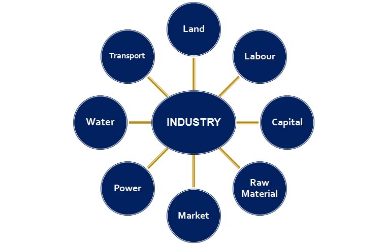
 

INDUSTRIAL LOCATION

Factors effecting the location of an Industry are: -


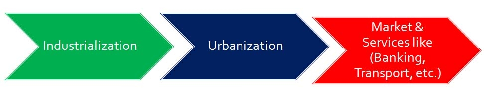
  • Industrialization leads to urbanization.


  • Government policies also play a key factor in deciding the location of an industry. The government provides incentives like subsidised power, lower transport cost and other infrastructure


INDUSTRIAL SYSTEM

An industrial system consists of inputs, processes and outputs.

Input: Raw materials, labour, costs of land, transport, power and other infrastructure.
Process: All activities that convert the raw material into finished products.
Output: End/ Final/Finished product and the income earned from it.


INDUSTRIAL REGIONS

  • The region where a number of industries locate close to each other and share the benefits of their closeness can be termed as Industrial regions.
  • Major industrial regions tend to be located in the temperate areas, near sea ports and especially near coal fields.

Industrial Regions of the World are: -
1. Great Lakes Industrial Region of North America.
2. Rhur-Saar Industrial Region of Europe.
3. London Industrial Region.
4. Ural-Ukraine Industrial Region of Russia.
5. Sydney Industrial Region of Australia.

Major industrial regions in India are: -
1. Mumbai-Pune cluster
2. Bangalore-Tamil Nadu region
3. Hugli region
4. Ahmedabad-Baroda region
5. Chottanagpur industrial belt
6. Vishakhapatnam-Guntur belt
7. Gurgaon-Delhi-Meerut region
8. Kollam-Thiruvanathapuram industrial cluster.


CLASSIFICATION OF INDUSTRIES


1. On the basis of Raw Materials: These types of industries are classified depending on the type of raw materials they use.

    (a) Agro Based Industries: Use plant and animal based products as their raw materials. E.g. Food processing, vegetable oil, cotton textile, dairy products, etc.
    (b) Mineral Based Industries: Primary industries that use mineral ores as their raw materials. The products of these industries feed other industries. Iron made from iron ore is the product of mineral based industry. E.g. Iron& Steel, Cement, Machine Tools, etc.
    (c) Marine Based Industries: Use products from the sea and oceans as raw materials. E.g. processed sea food, fish oil manufacturers, etc.
    (d) Forest Based Industries: Use forest produce as raw materials. E.g. pulp & paper, furniture. Pharmaceuticals, etc.

2. On the basis of Size: These types of industries are classified depending on the amount of capital invested, number of people employed and the volume of production.

    (a) Large Scale Industries: In India, on an industry, if the capital invested is more than 1 crore, then it is called Large Scale Industry. E.g. Iron & Steel Industries, Automobile Industries, etc.
    (b) Small Scale Industries: In India, on an industry, if the capital invested is less than 1 crore, then it is called Small Scale Industry. E.g. Silk weaving, Food processing industries, etc.

Cottage or household industries are a type of small scale industry where the products are manufactured by hand, by the artisans with the help of family members. E.g. Basket weaving, pottery, handicrafts, etc.

3. On the basis of Ownership: These types of industries are classified on the basis of ownership.

    (a) Private Sector Industries: Owned and operated by individuals or a group of individuals. E.g. Bajaj Auto, Reliance, etc.
    (b) Public Sector Industries: Owned and operated by the government. E.g. Hindustan Aeronautics Limited (HAL), Bharat Heavy Electronics Ltd. (BHEL), SAIL, etc.
    (c) Joint Sector Industries: Owned and operated by the state and individuals or a group of individuals. Maruti Udyog Limited. E.g. processed sea food, fish oil manufacturers, etc.
    (d) Co-operative Sector Industries: Owned and operated by the producers or suppliers of raw materials, workers or both. E.g. IFFCO, Anand Milk Union Limited (AMUL) and Sudha Dairy, etc.


INDUSTRIAL DISASTER
In industries, accidents/disasters mainly occur due to technical failure or irresponsible handling of hazardous material.

One of the worst industrial disasters of all time occurred in Bhopal on 3 December 1984 around 00:30 a.m. It was a technological accident in which highly poisonous Methyl Isocynate (MIC) gas along with Hydrogen Cyanide and other reaction products leaked out of the pesticide factory of Union Carbide. The official death toll was 3,598 in 1989. Thousands, who survived still suffer from one or many ailments like blindness, impaired immune system, gastrointestinal disorders etc.

Mitigation Strategies
1. Densely populated residential areas should be separated far away from the industrial areas.
2. People staying in the vicinity of industries should be aware of the storage of toxins or hazardous substances and their possible effects in case if an accident occurs.
3. Fire warning and fighting system should be improved.
4. Storage capacity of toxic substances should be limited.
5. Pollution dispersion qualities in the industries should be improved.


DISTRIBUTION OF MAJOR INDUSTRIES

The world's three major industries are:
1. Iron & Steel Industry
2. Textile Industry
3. Information Technology Industry

The iron & steel and textile industry are the older industries while information technology is an emerging industry.

EMERGING INDUSTRIES ARE ALSO KNOWN AS 'SUNRISE INDUSTRIES'


IRON & STEEL INDUSTRY:

  • This is basic industry.
  • These industries are the feeder industry whose products are used as raw material for other industries.
  • Inputs: Raw materials such as iron ore, coal and limestone, along with labour, capital, site and other infrastructure.
  • Process: Converting iron ore into steel involves many stages. The raw material is put in the blast furnace where it undergoes smelting and then it is refined.
  • Output: Steel is obtained which is used by other industries as raw material.
  • Steel is often called the backbone of modern industry.
  • Almost everything we use is either made of iron or steel or has been made with tools and machinery of these metals. From safety pin to Ships, trains, trucks, and autos are made largely of steel.
  • Before 1800 A.D. iron and steel industry was located where raw materials, power supply and running water were easily available.
  • Later the ideal location for the industry was near coal fields and close to canals and railways.
  • After 1950, iron and steel industry began to be located on large areas of flat land near sea ports.
  • India, Germany, USA, China, Japan, Russia, Korea, etc. are the countries, where steel industries are located.
  • In India important steel producing centres are: Bhilai, Durgapur, Burnpur, Jamshedpur, Rourkela, Bokaro are situated in a region that spreads over four states — West Bengal, Jharkhand, Odisha and Chhattisgarh.
  • Bhadravati and Vijay Nagar in Karnataka, Vishakhapatnam in Andhra Pradesh, Salem in Tamil Nadu are other important steel centres utilising local resources.
  • India's steel production increased from one million tonne in 1947 to 30 million tonnes in 2002.


Tata Iron and Steel Industry in Jamshedpur:

  • Before 1947, there was only one iron and steel plant in the country – Tata Iron and Steel Company Limited (TISCO).
  • It was privately owned.
  • TISCO was started in 1907 by Jamshedji N. Tata at Sakchi in the Singhbhum district of Jharkhand, but the production started in 1910. Later on Sakchi was renamed as Jamshedpur.

Sakchi was chosen to set up the steel plant because of the following reasons: -
1. This place was only 32 km away from Kalimati station on the Bengal-Nagpur railway line.
2. It was close to the iron ore, coal and manganese deposits as well as to Kolkata, which provided a large market.
3. TISCO gets coal from Jharia coalfields, and iron ore, limestone, dolomite and manganese from Orissa and Chhattisgarh.
4. The Kharkai and Subarnarekha rivers ensured sufficient water supply.
5. Government initiatives provided adequate capital for its later development. This lead to rapid industrial growth in India.


Iron and Steel Industry at Pittsburgh (USA):

  • It is an important steel city of the United States of America. Pittsburgh is also known as "Iron City"
  • In mid 19th century processing of Iron began in Pittsburgh.
  • The steel industry at Pittsburgh enjoys locational advantages. Some of the raw material such as coal is available locally, while the iron ore comes from the iron mines at Minnesota, about 1500 km from Pittsburgh. Between these mines and Pittsburgh is one of the world's best routes for shipping ore cheaply – the famous Great Lakes waterway. Trains carry the ore from the Great Lakes to the Pittsburgh area. The Ohio, the Monongahela and Allegheny rivers provide adequate water supply.
  • The Geographical conditions of Pittsburgh have a favourable topography, temperate climate, skilled labour and market, which make this place favourable for the development of Iron & Steel industry.


TEXTILE INDUSTRY:

  • Weaving cloth from yarn is an ancient art and it is done on looms. Hand operated looms are called Handlooms and power operated looms are called Powerlooms.
  • Cotton, wool, silk, jute, flax have been used for making cloth.
  • The textile industry can be divided on the basis of raw materials used in them.
  • Fibres are the raw material of textile industry. Fibres can be natural or man-made. Natural fibres are obtained from wool, silk, cotton, linen and jute. Manmade fibres include nylon, polyester, acrylic and rayon.
  • The cotton textile industry is one of the oldest industries in the world.
  • India has a glorious tradition of producing excellent quality cotton textiles. Before the British rule, Indian hand spun and hand woven cloth already had a wide market. The Muslins of Dhaka, Chintzes of Masulipatnam, Calicos of Calicut and Gold-wrought cotton of Burhanpur, Surat and Vadodara were known worldwide for their quality and design. But the production of hand woven cotton textile was expensive and time consuming. Hence, traditional cotton textile industry could not face the competition from the new textile mills of the West, which produced cheap and good quality fabrics through mechanized industrial units.
  • The first successful mechanized textile mill was established in Mumbai in 1854.
  • The warm, moist climate, a port for importing machinery, availability of raw material and skilled labour resulted in rapid expansion of the industry in the region.
  • Initially this industry flourished in the states of Maharashtra and Gujarat because of favourable humid climate.
  • Today, Coimbatore, Kanpur, Chennai, Ahmedabad, Mumbai, Kolkata, Ludhiana, Pondicherry and Panipat are some of the other important centres.


Ahmedabad:

  • It is located in Gujarat on the banks of the Sabarmati River.
  • The first mill was established in 1859. It soon became the second largest textile city of India, after Mumbai.
  • Ahmedabad was therefore often referred to as the 'Manchester of India'.
  • Favourable locational factors were responsible for the development of the textile industry in Ahmedabad.
  • Ahmedabad is situated very close to cotton growing area. This ensures easy availability of raw material.
  • The climate is ideal for spinning and weaving.
  • The flat terrain and easy availability of land is suitable for the establishment of the mills.
  • The densely populated states of Gujarat and Maharashtra provide both skilled and semi-skilled labour.
  • Well developed road and railway network permits easy transportation of textiles to different parts of the country, thus providing easy access to the market. Mumbai and Kandla ports nearby facilitates import of machinery and export of cotton textiles.

Osaka:

  • It is an important textile centre of Japan, also known as the 'Manchester of Japan'.
  • The extensive plain around Osaka ensured that land was easily available for the growth of cotton mills. Warm humid climate is well suited to spinning and weaving.
  • The river Yodo provides sufficient water for the mills.
  • Labour is easily available.
  • Location of port facilitates import of raw cotton and for exporting textiles.


INFORMATION TECHNOLOGY (IT):

  • Today, IT industry has become global and has become the fastest growing industry in the world.
  • The information technology industry deals in the storage, processing and distribution of information through Radio, Television, Telephones, Cellular Phones, Computers, Laptops, etc.
  • Availability of resources, cost and infrastructure are the main factors responsible for the location of an IT industry.
  • The major hubs of the IT industry are the Silicon Valley and Bangaluru in India.


Silicon Valley (California, USA):

  • Silicon Valley is a part of Santa Clara Valley, located on the San Francisco-California Peninsular in the USA.
  • Temperate climate is favourable for the industry.
  • Availability of skilled labour and market has played an important role in the grown of IT industry.


Bangaluru (Karnataka, India):

  • Bangalore is located on the Deccan Plateau from where it gets the name 'Silicon Plateau'.
  • The city is known for its mild climate throughout the year. Pleasant weather, low cost of living, makes it an ideal place for living.
  • Good transport facility, availability of skilled and experienced professionals.
  • More than 100 multinational and software companies have established their business.
  • Other emerging information technology hubs in metropolitan centres of India such as Mumbai, New Delhi, Hyderabad and Chennai, Gurgaon, Pune, Thiruvanthapuram, Kochi and Chandigarh, etc.


-----x-----X-----x-----


Class VII: Chapter 5 - Water

Some Facts and Figures of Water:

  • TWO-THIRD OF THE EARTH'S SURFACE IS COVERED WITH WATER.
  • Earth is also known as "Watery Planet", because 71% of the earth's surface is covered with water and only 29% is land.
  • World Water Day is celebrated on 22 March.


Distribution of Water:

1. 97% of the total volume of water is covered by Seas and Oceans

2. 3% as fresh water available on earth.

    (a) Out of 2% of the fresh water available, nearly 70% is in the form of "ICE" and is found in glaciers in Antarctica, Greenland, mountain regions, etc.

    (b) Only 1% of water is fit to use. It is found as underground water, surface water in rivers and lakes and also, water vapors' in the Atmosphere.


Water is available in three forms:

1. Water vapor's

2. Water in ocean, lakes & rivers

3. Ice in the glaciers & ice caps


HYDROLOGICAL CYCLE

  • The fresh water is continuously being renewed and recharged through hydrological cycle.
  • The sun's heat causes evaporation of water vapour.
  • When the water vapour cools down, it condenses and forms clouds.
  • From there it may fall on the land or sea in the form of rain, snow or sleet which is known as precipitation.
  • The process by which water continually changes its form and circulates between oceans, atmosphere and land is known as the Water Cycle or the Hydrological Cycle.


Usage of Water:

1. Drinking                                         2. Bathing                                           3. Washing

4.  Cooking                                        5. Irrigation                                         6. Construction, etc.

7. Water used in Industries                  8. Generating Electricity


PROBLEM OF WATER AVAILABILITY

  • Water is available in abundance and is renewable. Then why we suffer from water scarcity?
  • Water is not evenly divided around the world. Some places have lots and others have very little. Water supply is a big problem in some countries like, Africa, West Asia, South Asia, etc.

According to Mr. Falkenmark (a Swedish Expert), Water Stress Indicator, a country or region is said to experience "water stress" when annual water supplies drop below 1,700 cubic metres per person per year. At levels between 1,700 and 1,000 cubic metres per person per year, periodic or limited water shortages can be expected. When water supplies drop below 1,000 cubic metres per person per year, the country faces "water scarcity".


CONSERVATION OF WATER

Some of the important ways to conserve water are: -

1.  Decrease of water pollution:- Discharge of untreated sewage, agriculture chemicals & industrial effluents.

2.  Proper irrigation method.

     (a) Sprinklers can be used to irrigate very large area.

     (b) Drip irrigation can be used in dry regions, where evaporation is very high.

3.  Water Harvesting Method: This water can be used for cleaning, washing, gardening, etc.

4.  Water conservation in the home.

  • Check faucets and pipes for leaks.
  • Check your toilets for leaks.
  • Use your water meter to check for hidden water leaks.
  • Install water-saving shower heads and low-flow faucet aerators.
  • Put plastic bottles or float booster in your toilet tank.
  • Insulate your water pipes.
  • Take shorter showers.
  • Turn off the water after you wet your toothbrush.
  • Use your dishwasher and clothes washer for only full loads.
  • When washing dishes by hand, don't leave the water running for rinsing.


MOVEMENT OF OCEAN WATER OR OCEAN CIRCULATION

  • March 22 is celebrated as World Water Day.
  • Ocean water keeps moving continuously. It is never still.
  • The movements that occur in oceans can be broadly categorized as:Waves, Tides and Currents.


WAVES

  • When the water on the surface of the ocean rises and falls alternately, they are called waves.
  • During a storm, the winds blowing at very high speed form huge waves.
  • These may cause tremendous destruction.An earthquake, a volcanic eruption or underwater landslides can shift large amounts of ocean water. As a result a huge tidal wave called tsunami.
  • Tsunami is a Japanese word that means "Harbour waves" as the harbours get destroyed whenever there is tsunami. The term "Tsunami" has been derived from: - "Tsu" – Harbour and "Nami" – Waves. Meaning huge tidal waves.


TIDES

  • The rhythmic rise and fall of ocean water twice in a day is called a tide.
  • It is high tide when water covers much of the shore by rising to its highest level.
  • It is low tide when water falls to its lowest level and recedes from the shore.
  • During the full moon and new moon days, the sun, the moon and the earth are in the same line and the tides are highest. These tides are called spring tides.
  • But when the moon is in its first and last quarter, the ocean waters get drawn in diagonally opposite directions by the gravitational pull of sun and earth resulting in low tides. These tides are called neap tides.
  • High tides help in navigation.
  • This helps the ships to arrive at the harbour more easily.
  • The high tides also help in fishing.
  • Also, the rise and fall of water due to tides is being used to generate electricity in some places.


OCEAN CURRENTS

The horizontal movement of ocean water in the form of streams flowing constantly in definite directions is known as Ocean Currents.


Factors affecting the Ocean Currents: -

1.  Planetary Winds

2.  Rotation of the Earth

3.   Variation in the temperature

4.  Density of ocean water

5.  Shapes of  the coastlines


  • The ocean currents may be warm or cold.
  • The warm ocean currents originate near the equator and move towards the poles.
  • The cold currents carry water from polar or higher latitudes to tropical or lower latitudes.
  • The ocean current influence the temperature conditions of the area.
  • The place where warm and cold currents meet, dens fog is produced, reducing the visibility and thus, making it difficult for navigation. But at the same time these are the best fishing grounds of the world.
  • The general circulation of ocean currents is clockwise in the Northern Hemisphere and anti-clockwise in the Southern Hemisphere.


CASE STUDY

(TSUNAMI IN THE INDIAN OCEAN ON 26 DECEMBER 2004)

  • Tsunami or the harbour wave struck havoc in the Indian Ocean on the 26 December 2004.
  • The wave was the result of the earthquake that had its epicenter close to the western boundary of Sumatra in Indonesia.
  • The magnitude of the earthquake was 9.0 on the Richter scale.
  • Tsunami affected the coastlines of South and Southeast Asian countries. India, Indonesia, Sri Lanka, Thailand, etc were some of the countries where destruction was maximum.
  • Tsunami travelled at a speed of about 800km. per hour and completely washed away some of the islands in the Indian ocean.
  • The Indira point in the Andaman and Nicobar islands that marked the southernmost point of India got completely submerged. In India, the worst affected were the coastal areas of Andhra Pradesh, Tamil Nadu, Kerala, Puducherry and the Andaman and Nicobar Islands.
  • The earthquake-induced tsunami resulted in at least 1.8 lakh dead, 500,000 injuries, and damages that exceeded $10 billion. Also, it is estimated that 5 million people lost their homes or access to food and water.
  • Relief work was carried out at a great speed. All types of helps were received from all the corners of the world. Serious efforts were made by the government and non-government agencies to bring back life of the leftovers on track.


-----x-----X-----x-----

Extra Question for Practice (Class IX, Chapter 4 - Climate)

Q1. Differentiate between south-west monsoon and north- east monsoon.

Q2. What is the role of "Western Disturbances" in the India?

Q3. What do you understand by the phenomenon of ENSO?

Q4. What is Jet stream? How do they affect the climate?

Q5. What are the six major controls of the climate of the World?

Q6. State the factors which help us understand the mechanism of Monsoon?

Q7. What do you know about the onset of Monsoon?

Q8. Why does the rainfall decreases from east to the west in Northern India?

Q9. Why Monsoon is considered a unifying bond?

Q10. What do you understand by the phenomenon of breaks in the rainfall?


-----x-----X-----x-----

Class IX: Chapter 4 (Climate) MCQ's Test (29 Nov 2014) - Answer Key

Multiple choice type questions:

1. What generally happens to air temperature as we move from the equator to the poles?
(a) it decreases
(b) it increases
(c) it remains constant
(d) None of the above

2. Monsoon arrives in India approximately in:
(a) Early May
(b) Early June
(c) Early July
(d) Early August

3. Which one of the following warm ocean currents replaces the Peruvian cold currents?
(a) Kuroshio
(b) El Nino
(c) South Pacific Currents
(d) Gulf Stream

4. Which is the coldest place in India?
(a) Dras
(b) Srinagar
(c) Shimla
(d) Jaipur

5. Which of the following states suffer from loo?
(a) Tamil Nadu
(b) Uttar Pradesh
(c) Gujarat
(d) None of these

6. What is the full form of ITCZ
(a) International Tropical Convergence Zone
(b) Interstate Tropical Convergence Zone
(c) International Tropical Convergent Zone
(d) Inter Tropical Convergence Zone

7. The amount of ....................... present in the atmosphere is called Humidity
(a) Smog
(b) Dust
(c) Pollution
(d) Water Vapours

8. Which one of the following characterises the cold weather season in India?
(a) Warm days and warm nights
(b) Warm days and cold nights
(c) Cool days and cold nights
(d) Cold days and warm nights

9. Which of the crop is associated with the winter rainfall?
(a) Zaid
(b) Rabi
(c) Kharif
(d) None of these

10. Mawsynram ................ place on the earth is also famous for its stalagmites and stalactite caves.
(a) Coldest
(b) Hottest
(c) Wettest
(d) Driest

11. The term monsoon originates from
(a) German
(b) Hindi
(c) Latin
(d) Arabic

12. Which of the following forces is responsible for the deflection of winds from its normal path?
(a) Centripetal Force
(b) Coriolis Force
(c) Applied Force
(d) Gravitational Force

13. Mango showers helps in ripening of
(a) Apples
(b) Mangoes
(c) Bananas
(d) Coconut

14. Which one of the following causes rainfall during winters in north-western part of India?
(a) Cyclonic depression
(b) Western disturbances
(c) Retreating monsoon
(d) Southwest monsoon

15. Mawsynram is located in which of the hills?
(a) Garo Hills
(b) Jainita Hills
(c) Khasi Hills
(d) Shillong Hills

16. Which of the following areas is not an area of low precipitation?
(a) Western parts of Gujarat
(b) Leh in Jammu & Kashmir
(c) Deccan Plateau
(d) Assam

17. Fast flowing and narrow air currents are called
(a) Monsoon
(b) Cyclone
(c) Jet Streams
(d) Anticyclone

18. Wind generally blow from areas of
(a) Low Pressure to High Pressure
(b) High Pressure to Low Pressure
(c) Low Pressure to Moderate Pressure
(d) None of these

19. How many seasons do we have in India?
(a) 2
(b) 3
(c) 4
(d) 5

20. In which latitude of tropical areas are monsoon experienced?
(a) 20oN and 20oE
(b) 20oN and 20oS
(c) 20oN and 20oW
(d) 20oE and 20oW

21. Which one of the following is an element of weather?
(a) Climate
(b) Temperature
(c) Humidity
(d) Both (b) & (c)

22. Which imaginary line passes through the centre of our country?
(a) Equator
(b) Tropic of Capricon
(c) Tropic of Cancer
(d) None of these

23. The state of the atmosphere over an area at any point of time is called
(a) Temperature
(b) Climate
(c) Weather
(d) Air Pressure

24. Which of the following control is not affecting the climate of India?
(a) Altitude
(b) Cyclones
(c) Latitude
(d) Pressure & Winds

25. The seasonal reversal in wind direction during a year is called
(a) Monsoon
(b) Cyclone
(c) Jet Streams
(d) Anticyclone


-----x-----X-----x-----

Class IX: Chapter 4 (Climate) Question & Answer

Answer the following questions briefly

Q1. What are the controls affecting the climate of India?
Ans: Latitude, Altitude and Pressure & Winds are the main controls affecting the climate of India.

Q2. Why does India have a monsoon type of climate?
Ans: In India we find monsoon type of climate, following are the factors responsible for these monsoons:
(a) The differential heating and cooling of land and water.
(b) The shift of the position of Inter Tropical Convergence Zone (ITCZ).
(c) Presence of high pressure in the east of Madagascar.
(d) The Tibetan plateau gets intensely heated during summers.
(e) Movement of westerly jet streams to the north of Himalayas and the presence of tropical

Q3. Which part of India does experience the highest diurnal range of temperature and why?
Ans: Diurnal range of temperature is the difference between maximum and minimum temperature of a day. Diurnal range of temperature is high in the deserts like Rajasthan, Thar Desert and interior parts of Rann of Kutch. In these sandy areas the day temperature may raise upto 50oC and by night the temperature drops down to nearly freezing point. This happens because during the day time, sand absorbs heat very fast and at the same time loses heat very fast at night.

Q4. Which winds account for rainfall along the Malabar coast?
Ans: Monsoon winds are accountable for rainfall along the Malabar coast.

Q5. What are Jet streams and how do they affect the climate of India?
Ans: Fast flowing and narrow air currents are called jet streams. The streams flow at high altitudes (about 12,000 feet) in the troposphere. The westerly jet streams are responsible for western cyclonic disturbances in the north and north-western parts of India. The subtropical westerly jet stream moves north of the Himalayas with the apparent movement of the sun. The tropical jet stream (an easterly jet stream) blows over the Indian Peninsula; approximately over 14° north during the summer months.
These jet streams are amongst one of the major factors in determining the movement of monsoons winds towards India sub-continent.

Q6. Define monsoons. What do you understand by "break" in monsoon?
Ans: The seasonal reversal in wind direction during a year is called monsoon. Monsoon tends to have 'breaks' in rainfall; which means that there are wet and dry spells in between. The monsoon rains take place only for a few days at a time and then come the rainless intervals.

Q7. Why the monsoon is considered a unifying bond?
Ans: Although there are wide variations in weather patterns across India, the monsoon brings some unifying influences on India. Following are few of the reasons why the monsoon is considered as a unifying bond in India:
(a) The Indian landscape, its flora and fauna, etc. are highly influenced by the monsoon.
(b) The entire agricultural calendar in India is governed by the monsoon.
(c) Most of the festivals in India are related to agricultural cycle. These festivals may be known by different names in different parts of the country, but their celebration is decided by the monsoon.
(d) It is also said that the river valleys which carry the rainwater also unite as a single river valley unit.

Q8. Why does the rainfall decrease from the east to the west in Northern India?
Ans: The Bay of Bengal branch of the monsoon winds moves towards northeast and return westwards covering the northern plains. While they move towards west, their moisture contains tends to reduce with subsequent rains. Hence the rainfall decreases from east to west in northern India.


Give reasons as to why.

Q9. Seasonal reversal of wind direction takes place over the Indian subcontinent?
Ans: Seasonal reversal of wind direction over the Indian subcontinent takes place due to pressure differential. El Nino has major role to play in the seasonal reversal of wind direction over the Indian subcontinent.

Q10. The bulk of rainfall in India is concentrated over a few months.
Ans: The monsoon begins from the first week of June and advances quite rapidly to cover almost the whole country by mid-July. Hence, the bulk of rainfall in India is concentrated over the months of a few months; mainly June to August.

Q11. The Tamil Nadu coast receives winter rainfall.
Ans: The Tami Nadu coast receives winter rainfall because of movement of low-pressure conditions to the Bay of Bengal.

Q12. The delta region of the eastern coast is frequently struck by cyclones.
Ans: The Bay of Bengal is the centre of various pressure changes and hence there is always a chance of development of cyclone. Due to this, the delta region of the eastern coast is frequently struck by cyclones.

Q13. Parts of Rajasthan, Gujarat and the leeward side of the Western Ghats are drought-prone.
Ans: The parts fall in the rain shadow area of the Aravalli. Hence, they are drought prone and don't receive much of rainfall.

Q14. Describe the regional variations in the climatic conditions of India with the help of suitable examples.
Ans: There is regional variation in the climatic conditions of India. Temperature and Precipitation vary from place to place and season to season.
(a) In summers the temperature rises up to 50°C in parts of Rajasthan, whereas it may be around 20°C in Pahalgam in Kashmir.
(b) In winters night temperature in Drass in Kashmir may be minus 45°C, whereas in Tiruvanantapuram in Kerala may have a temperature of 20°C.
(c) In Andaman Islands the difference between day and night temperature may be hardly 7° - 8°C.
(d) Coastal areas experience less contrast in the temperature, whereas seasonal contrasts are more in the interior of the country.
(e) There is decrease in rainfall generally from east to west in the northern plains.
(f) Most part of India get rainfall from June – September, whereas Coromandel Coast gets rainfall in winter season.

Q15. Discuss the mechanism of monsoons.
Ans: Following are the factors responsible for the mechanism of monsoon:
(a) The Sun causes differential heating and cooling of land and water. This creates low pressure on the landmass of India and high pressure over the ocean surface.
(b) The Inter Tropical Convergence Zone (ITCZ) is normally positioned about 5°N of the equator. It shifts over the Ganga plains during summer. It is also known as the monsoon trough during the monsoon season.
(c) The high pressure area, east of Madagascar is approximately 20°S over the Indian Ocean. This area affects the Indian Monsoon.
(d) The Tibetan plateau gets intensely heated during summer. This results in strong vertical air currents and formation of high pressure over the plateau. This high pressure zone is about 9 km above the sea level.
(e) The westerly jet stream move to the north of the Himalayas, and the tropical easterly jet stream moves over the Indian Peninsula during summer.
(f) The periodic change in pressure conditions between Pacific Ocean and the Indian Ocean that is known as the Southern Oscillation or SO also affects the monsoon.
(g) The difference in pressure over Tahiti and Darwin is computed to predict the intensity of the monsoons. Tahiti (18°S/149°W) lies in the Pacific Ocean and Darwin (12°30'S/131°E) lies in northern Australia. If the pressure differences are negative, it means a below average and late monsoon.

Q16. Give an account of weather conditions and characteristics of the cold season.
Ans: Following are the features of the cold season:
(a) The winter season begins from mid-November and till February; in northern India.
(b) December and January are the coldest months in the northern part of India.
(c) The temperature ranges between 10°-15°C in the northern plains, while it ranges between 24°-25°C in Chennai.
(d) The northeast trade winds prevail over the country in this season. As these winds blow from land to sea, most parts of the country experience a dry season.
(e) The weather is usually marked by clear sky, low temperatures and low humidity and weak variable winds.
(f) The inflow of the cyclonic disturbances from the west and the northwest is a characteristic feature of the cold weather over the northern plains.
(g) These low-pressure systems originate over the Mediterranean Sea and Western Asia and move into India. They cause winter rains over the plains and snowfall in the mountains.
(h) The winter rainfall is in small amount but is very important for the rabi crop. This rainfall is locally known as mahawat.
(i) The peninsular region does not get a well-defined winter because of the moderating influence of the sea.

Q17. Give the characteristics and effects of the monsoon rainfall in India.
Ans:
Characteristics of the monsoon rainfall in India:
(a) The duration of the monsoon varies from 100 to 120 days from early June to mid- September.
(b) Around the time of its arrival, the normal rainfall increase suddenly and continues regularly for several days. This is called the 'burst' of the monsoon.
(c) They are distinguished from the pre-monsoon showers because of their increase in rainfall amount and regularity.
(d) The monsoon arrives at the southern tip of the Indian Peninsular generally by the first week of June.
(e) The rainfall is unevenly distributed across the country.

Effects of the monsoon rainfall in India:
(a) Agriculture in India largely depends on Indian monsoons for water. Late, Low or excessive rains have a negative impact upon crops.
(b) Due to uneven distribution of rainfall across the country, there are few places that are drought prone and few are flood affected.
(c) The monsoon provides India with a diverse climatic pattern. Hence, in spite of the presence of great regional variations, it has a unifying influence upon the country and its people.


-----x-----X-----x-----

Newer posts → Home ← Older posts