Nirman Care - an educational blog

Pre-Summative – II (Social Science, Class – IX)


Time allowed: 3 hours                                                                                                           Maximum Marks: 90

General Instructions:
The question paper has 30 questions in all.
All questions are compulsory. Marks are indicated against each question.
I. Questions from serial number 1 to 8 carry one mark each.
II. Questions from serial number 9 to 20 are 3 marks questions. Answer of these questions should not exceed 80 words each.
III. Questions from serial number 21 to 28 are 5 marks questions. Answer of these questions should not exceed 120 words each.
IV. Question number 29 and 30 are map questions of 3 marks each from History and Geography respectively. After completion, attach the map inside your answer book.

***************************************************************************************************************

Q1.What was the main object of National Assembly in France while drafting the constitution in 1791?
Q2. Which drainage pattern is formed by River Ganga?
Q3 .Which is the western most longitude of India?
Q4. Name the part of Himalaya lying between Kali and Tista rivers.
Q5. Pinochet rule in Chile ended after he decided to hold a referendum. In which year was referendum held?
Q6. When did Mexico get independence?
Q7.How much time did it take the Constituent Assembly to complete the Indian Constitution?
Q8 .What was the expenditure percentage of GDP in 1951-52 on education?
Q9. Describe the events of 14th July 1789.
Q10 (a) Who were radicals? Describe briefly.
                                    OR
10 (b) Explain the new education policy introduced by Hitler in Germany.
Q11 (a) Explain any three differences between the political ideas of Liberals and Radicals in Russia during the early twentieth century.
                                    OR
11(b) Highlight three main features of the Nazi World view?
Q12. India accounts for about 2.4 percent of the total geographical area of the world but supports the second largest population of the world. What are its three implications?
Q13. Justify the naming of Indian Ocean after India.
Q14. Mention any six tectonics plates of the earth's crust.
Q15. Name the three sections into which Northern plain has been divided. Write one feature of each.
Q16. How did Robert Mugabe's party ZANU PF violate the features of a democratically elected government? Mention any three methods adopted by the party.
Q17. ‟The Constituent Assembly worked in a systematic open and consensual manner." Mention any three values that are depicted by the Constituent Assembly.
Q18. Describe any three demands of the workers of "Lenin Shipyard" during their strike which started in August 1980 in Poland.
Q19. Describe any three ways by which production can be increased from a fixed plot of land.
Q20. What does a "virtuous cycle" created by the educated parents mean? Explain.
Q21. Explain the immediate causes of the outbreak of the revolt in France in 1789.
Q22 (a) Explain any five socio – economic conditions of Russia at the beginning of the twentieth century?
                                       OR
22 (b) Hitler's foreign policy aimed at gaining power and prestige for Germany. State this features of his foreign policy.
Q23. Give an account of the four divisions of Himalayas from west to east along with Purvanchal hills respectively.
Q24. Even democracy has a fair share of demerits. Point out five such demerits.
Q25. Highlight the salient features of the Constitution of India.
Q26. Explain the meaning of "Physical Capital"? Explain its two types with the help of suitable examples.
Q27. Explain any five effects of unemployment in India.
Q28. "Green Revolution is associated with loss of soil fertility". In the light of the statement mention five problems caused by modern farming.
Q29. Three items A, B and C are shown in the given outline map of France. Identify these items with the help of following information and write their correct names on the lines marked on the map.
(A) Port related to slave trade.
(B) The region not affected by the great fear.
(C) The place where French revolution of 1789 started.


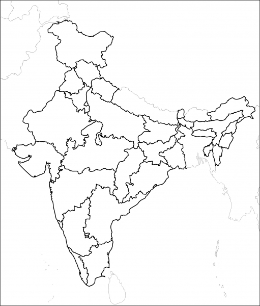
Q30. On the given political outline map of India, locate and label the following with appropriate symbols:
(X) Standard Meridian of India
(Y) Jaintia Hills
(Z) River Tapi


-----x-----X-----x-----

Pre-Summative (Answer Key - Geography) Class IX

Q2. Which is the largest river of the Peninsular Plateau? (1)
Ans 2: Largest River of the Peninsular Plateau is Godavari.

Q3. What do the lofty peaks represent about the age of the Himalayas? (1)
Ans 3: The Great Himalayas are also known as the young fold mountains. The lofty peaks also represent the same. It reflects the strength of the Himalayas, as they are standing big and strong. Although the Himalayas were formed millions of years ago but still they are growing and are considered as the young mountains.

Q4. What is the degree of longitude of westernmost tip of India lying in Gujarat? (1)
Ans 4: 68o 7' East is the degree of longitude of westernmost tip of India lying in Gujarat.

Q12. Describe any three important features of the Godavari Basin. (3)
Ans 12: Important features of the Godavari Basin are:
(a) This is the longest Peninsular River.
(b) This river is popularly known as "Dakshin Ganga".
(c) Its drainage basin is also the largest among the peninsular river basins.
(d) The Godavari is about 1500 km long.
(e) It originates from the slopes of the Western Ghats in Nasik district of Maharashtra and drains into the Bay of Bengal.
(f) The Godavari basin covers parts of Maharashtra, Madhya Pradesh, Orissa and Andhra Pradesh.
(g) Purna, Wardha, Pranhita, Manjra, Waiganga and Penganga are the main tributaries of Godavari.

Q13. What was the need for selecting the standard meridian of India? Explain. (3)
Ans 13: The longitudinal extent of India is 30 degrees. The sun rises in the east and sets in the west, it takes 4 minutes for the sun to move across 1 longitude. Thus, the eastern most point of India would be 2 hours ahead of the western most point (30 x 4 = 120 minutes), in accordance with the local time. This difference in time might create confusion in air and rail timings and so many other things across the two states. To avoid this confusion a longitude passing through the midpoint of 68o7' East (western most longitude) and 97o25' East (eastern most longitude) is taken as the standard prime meridian of India. Thus, 82o30' East longitude is taken as the Standard Time Meridian of India, as it passes through the middle of India (Mirzapur in Uttar Pradesh). With this same time is followed all over the country, making standard meridian of India very important for the smooth functioning.

Q14. Why is the Northern plain of India more productive agriculturally? Give three reasons. (3)
Ans 14: The northern plain of India is formed by three major river systems of India, i.e. the Indus, the Ganga and the Brahmaputra; along with their tributaries. The Northern plains of India are considered to be the area of large agricultural production. Following are the major reasons in making the northern plains of India more productive agriculturally:
(a) Soil: This plain is composed of alluvial soil which has been deposited over millions of years. Alluvial soil is considered to be the most fertile soil, because of the fertility of the soil this region is agriculturally very productive.

(b) Water: The plains are drained by the three major rivers of India the Indus, the Ganga and the Brahmaputra and all these rivers are perennial in nature. Thus, the availability of water is there through out the year.

(c) Climate: The climatic conditions in the northern plains are very favourable for growing up of major staple crops of India making the area suitable for agricultural products.

Q15. Why are large number of meanders found in the Northern plains of India? (3)
Ans 15: Curves and large bends or loops formed by rivers in the plains are known as meanders. Rivers are the most important agents of degradation. As the river flows from the mountainous regions, it has great erosive power. Speed and force of water is more, during this course river does lots of erosional work. As the river enters into the plains, all of sudden the speed of flow of water is reduced to a greater extent and the river widens. As the flow of river slows down, it is not able to carry the eroded material brought from the mountains, which leads to the deposition of sediments on the river banks. Thus, because of the flat land, reduced flow of water and deposition of sediments we, find large number of meanders found in the Northern plains of India.

Q23. Name two coastal strips of the Peninsular plateau of India. Describe two characteristics of each. (5)
Ans 23: Eastern coastal plains and the Western coastal plains are the two main coastal strips of the Peninsular plateau of India. Characteristics of Eastern and Western coastal plains are as follows:

The Western Coastal Plains:
(a) It lays along the Arabian Sea on the west.
(b) It is a thin strip of coastal plain with a width of 50 kms between the Arabian Sea and the Western Ghats.
(c) It is divided into three sections. The Konkan; (Mumbai – Goa) in the north. The Kannada Plain makes the central part and the Malabar coast stretches in the south.

The Eastern Coastal Plains:
(a) It lays along the Bay of Bengal on the east.
(b) It is a strip of coastal plain with a width of 100 - 130 kms between the Bay of Bengal and the Eastern Ghats.
(c) It is divided into two parts. The northern part is called Northern Circar. The southern part is called the Coromandel Coast.
(d) Extensive deltas are formed by large rivers like Mahanadi, Godavari, Krishna and Kaveri.

Q30. On the given political outline map of India, locate and label the following with appropriate symbols (3)
(X) Standard Meridian of India (Y) Bomdila Pass (Z) Chilika Lake
Ans 30:


-----x-----X-----x-----

SA-I (Answer Key - Geography) Class VIII

Multiple choice questions:

Q1. Which one the following is not ubiquitous resource? (1)
(a) Sunlight (b) Air (c) Gold (d) Water

Ans 1: (c) Gold

Q2. Counter ploughing and terrace cultivation is common along. (1)
(a) River valley (b) Steep slopes (c) Deltas (d) Plains

Ans 2: (b) Steep slopes


Very short answer questions:

Q3. The process of sliding of huge debris, rocks and other materials down the slop is called? (1)
Ans 3: Sliding of huge debris, rocks and other material down the slope is know as "Landslides".

Q4. Reserved protecting area of the forest and wildlife. (1)
Ans 4: Areas where forest and wildlife are preserved and protected together are called National Parks.

Q5. Resources which are found to local regions are called? (1)
Ans 5: Resources which are found only in certain places or is local regions are called are localized resources.


Short answer questions:

Q6. Differentiate between natural and manmade resources. (2)
Ans 6:

Q7. What are the factors responsible for soil formation? (2)
Ans 7: Following are the Factors responsible for the Formation of Soil:
(a) Relief – Altitude and slope determines the accumulation of soil.
(b) Parent Rock – It determines, colour, texture, chemical properties, mineral contents, etc.
(c) Climate – Rainfall and temperature influence rate of humus and weathering.
(d) Time – It determines thickness of soil profile.
(e) Organisms – Microorganisms & vegetation affect the rate of humus formation.

Q8. Distinguish between metallic and non metallic minerals. (2)
Ans 8:


Medium answer questions:

Q9. What is sustainable development? List out the four principles of sustainable development. (3)
Ans 9: Balancing the need to use resources and also conserve them for the future is called sustainable development. Some of the Principles of Sustainable Development are:
(a) Respect and care for all forms of life.
(b) Improve the quality of human life.
(c) Conserve the earth's vitality and diversity.
(d) Minimize the depletion of natural resources.
(e) Change personal attitude and practices toward the environment.
(f) Enable communities to care for their own environment.

Q10. What is mineral? Why minerals are important to us? (3)
Ans 10: A naturally occurring substance that has a definite chemical composition is known as a mineral. Minerals are very important to us because of the following reasons:
(a) Backbone of Industries.
(b) Necessary for the production of all types of tools, machines, implements, etc.
(c) Construction Work.
(d) Maintain health of the people.
(e) Manufacturing of jewellery, utensils, etc.

Q11. What steps have been taken to conserve forest and wildlife? (3)
Ans 11: Following are few steps that have been taken to conserve forest and wildlife:
(a) National Forest Policy framed by the government should be implemented.
(b) National Parks, Wildlife Sanctuaries, Bioreserves, Botanical Gardens have been setup.
(c) Special Projects (E.g. Project Tiger, Project Elephant, etc.).
(d) Celebration of Van Mahotsav.
(e) Every National festival is followed by tree plantation ceremony.
(f) Large scale afforestation or planting of tress is undertaken.
(g) Controlling of deforestation and overgrazing.
(h) Practices like shifting agriculture have been stopped.
(i) Social Awareness Programmes to be implemented.
(j) Wildlife Protection Act 1972.


Long answer questions:

Q12.Define the Non conventional sources of energy and explain any four types of it. (5)
Ans 12: Non- conventional sources of energy are recently developed sources of energy from Sun, wind, water, tides, geothermal, etc. These sources are renewable. They are Eco friendly sources of energy. Following are the different sources of Non- conventional sources of energy:
1. Solar Energy: Solar energy trapped from the sun can be used in solar cells to produce electricity. Many of these cells are joined into solar panels to generate power for heating and lighting purpose. The technology of utilizing solar energy benefits a lot of tropical countries that are blessed with abundant sun shine. Solar energy is also used in solar heaters, solar cookers, solar dryers besides being used for community lighting and traffic signals.

2. Wind Energy: Wind is an inexhaustible source of energy. In modern time wind mills, the high speed winds rotate the wind mill which is connected to a generator to produce electricity. Wind farms having clusters of such wind mills are located in coastal regions and in mountain passes where strong and steady winds blow. Windfarms are found in Netherlands, Germany, Denmark, UK, USA and Spain are noted for their wind energy production. In India, the largest windfarm cluster is located in Tamil Nadu from Nagercoil to Madurai.

3. Nuclear Power: Nuclear power is obtained from energy stored in the nuclei of atoms of naturally occurring radio active elements like Uranium and Thorium. These fuels undergo nuclear fission in nuclear reactors and emit power. The greatest producers of nuclear power are USA and Europe. The nuclear power stations in India are located in Kalpakkam in Tamilnadu, Tarapur in Maharashtra, Rawatbhata in Rajasthan, Kakrapara in Gujarat, Narora in Uttar Pradesh and Kaiga in Karnataka.

4. Geothermal Energy: Heat energy obtained from the earth is called geothermal energy. The temperature in the interior of the earth rises steadily as we go deeper. Sometimes this heat energy may surface itself in the form of hot springs. This heat energy can be used to generate power. Geothermal energy in the form of hot springs has been used for cooking, heating and bathing, etc. USA has the world's largest geothermal power plants followed by New Zealand, Iceland, Philippines and Central America. In India, geothermal plants are located in Manikaran in Himachal Pradesh and Puga Valley in Ladakh.

5. Tidal Energy: Energy generated from tides is called tidal energy. Tidal energy can be obtained by building dams at narrow openings of the sea. During high tide the energy of the tides is used to turn the turbine installed in the dam to produce electricity. Russia, France and the Gulf of Kachchh in India have huge tidal mill farms.

6. Biogas: Organic waste such as dead plant and animal material, animal dung and kitchen waste can be converted into a gaseous fuel called biogas. The organic waste is decomposed by bacteria in biogas digesters to emit biogas which is essentially a mixture of methane and carbon dioxide. Biogas is an excellent fuel for cooking and lighting and produces huge amount of organic manure.

Q13. Explain any five methods of soil conservation. (5)
Ans 13: Soil conservation means the protection, preservation and proper utilization of the soil. Some methods of soil conservation are:
1. Mulching – Bare ground between plants is covered with a layer of organic matter like straw. It helps to retail soil moisture.
2. Contour Ploughing – Ploughing along contours can decrease the flow of water down the slopes.
3. Terrace Cultivation – Steps can be cut out on the slopes making terraces.
4. Strip Cropping – Strips of grass are grown between the crops. This breaks the force of wind.
5. Shelter Belts – Rows of trees are planted to create shelter. Thus, the speed of wind is reduced.
6. Rock Dam – Rocks are piled to slow the speed of wind.
7. Contour Barriers – Stones, grass and soil are used to make barriers. Trenches are made in front of the barriers to collect water.
8. Afforestation, Crop Rotation, Control over Deforestation and Overgrazing, etc.


-----x-----X-----x-----

SA-I (Answer Key - Geography) Class VII

Multiple choice questions:

Q1. .............. environment consists of plants, animals and human beings. (1)
(a) Abiotic (b) Chemical (c) Human (d) Biotic

Ans: (d) Biotic

Q2. "NIFE" is related to which layer of the earth? (1)
(a) Core (b) Mantle (c) Crust (d) Mountains

Ans: (a) Core


Very short answer questions:

Q3. Study of relationship between living organisms and their surrounding is called? (1)
Ans: Study of relationship between living organisms and their surrounding is called Ecology.

Q4. Fossil fuels are found in which type of rocks? (1)
Ans: Fossil fuels are found in Sedimentary rocks.

Q5. What is oceanic crust called? (1)
Ans: The ocean crust is called SIMA.


Short answer questions:

Q6. What is lithosphere? Why it is important? (2)
Ans: The hard outermost solid layer of the earth which is made up of rock material is called crust. This solid crust of the earth is called Lithosphere. On this lithosphere we find different landforms such as the mountains, plateaus and plains. It provides us land where we live and also, it is a great source of vegetation, wildlife and mineral wealth. The crust is covered by a thin layer of soil which is of great importance for life. Lithosphere provides us the three basic necessities of life, i.e. Food, Cloth and Shelter.

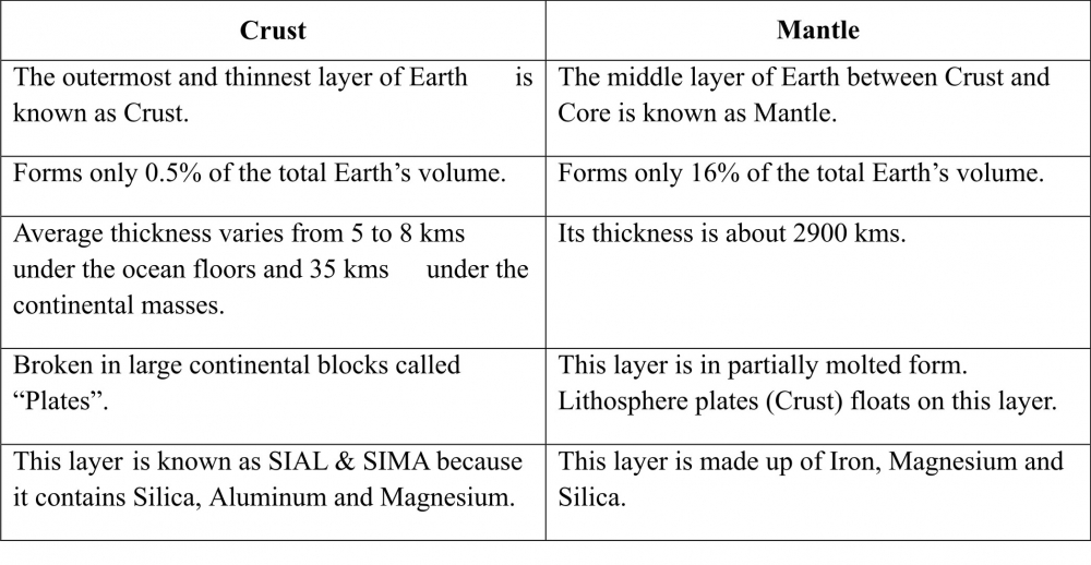
Q7. Distinguish between: Crust and Mantle. (2)
Ans:

Q8. Define the terms: (a) Focus (b) Epicenter (2)
Ans:
(a) Focus: The point of origin of an earthquake is called its Focus.
(b) Epicenter The point directly/vertically above the focus on the earth's surface is known as Epicenter.


Medium answer questions:

Q9. What is igneous rock? Write its main features. (3)
Ans: The word 'Igneous' is derived from Latin word "Ignis" meaning "Fire". This is also called Primary rock. These are the first rocks to be formed and are known as the ancestors of all the rocks. Igneous rocks are the hardest rocks available and it is formed by cooling and solidification of the Lava coming out from the interior of the Earth's interior. E.g. Granite, Basalt, etc. Igneous rocks are of two types:
(a) Solidification of rocks below the earth's surface is known "Intrusive rocks".
(b) The magma which reaches the earth's surface and gets solidified is known as "Extrusive Rocks".

Features of igneous rocks are:
1. These rocks do not form layers.
2. They contain crystals of varying sizes.
3. They do not contain fossils.

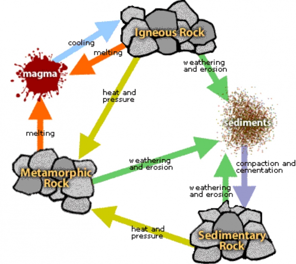
Q10. Describe the rock cycle with a suitable diagram. (3)
Ans: Rocks undergo a cycle of transformation. Change into sedimentary rock or into metamorphic rock. Sedimentary rock can change into metamorphic rock or into igneous rock. Metamorphic rock can change into igneous or sedimentary rock. Hence, this cycle of change from one type of rock to another is called 'rock cycle'.

Rocks are continually being formed, destroyed and reformed due to changing weather conditions and forces of nature (eg. Wind, river, glaciers, earth movements, etc.)

Q11. Explain the types of volcanoes? (3)
Ans: Natural openings in the earth's crust through which molten materials, rocks, ashes, gases, etc are thrown out are called 'Volcanoes'. Volcanoes are classified into three types:
(a) Active Volcanoes: These volcanoes erupt frequently and give out gases, ash, lava, etc. e.g. Mt. Etna in Italy.
(b) Dormant Volcanoes: These are also known as 'Sleeping Volcanoes'. They erupt after a very long time. E.g. Mt. Vesuvius in Italy.
(c) Extinct Volcanoes: These are also known as 'Dead Volcanoes'. They have been inactive since a very long time. E.g. Mt. Kilimanjaro in East Africa.
Long answer questions:

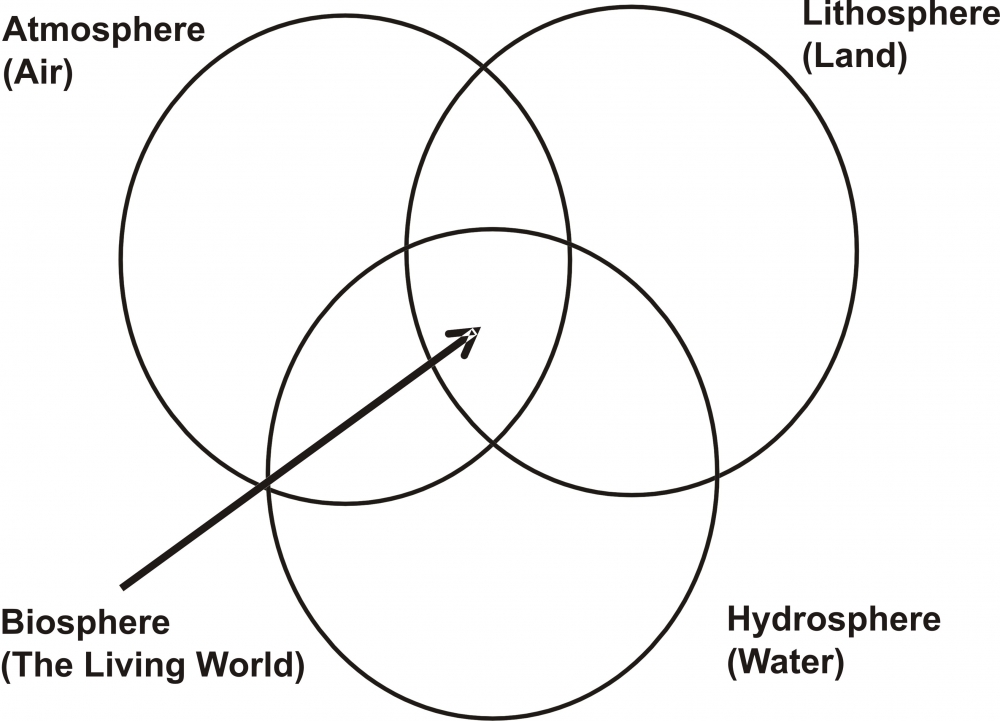
Q12. With a suitable diagram write a note on the domains of the earth. (5)
Ans:
Lithosphere: The solid crust of the earth is called Lithosphere.
Hydrosphere: The water bodies on the earth's surface together form the Hydrosphere.
Atmosphere: The layer of air around us is called Atmosphere.
Biosphere: The living world where land, water & air interact with each other to support life is called the Biosphere.
Plant and animal kingdom together make Biosphere or the living worlds. It is a narrow zone of the Earth where Air (Atmosphere), Water (Hydrosphere) and Land (Lithosphere) interact with each other to support life. All the three spheres are equally important for the existence of life or the Biosphere.

Q13. Explain the following. (5)
(a) Aggradation (b) Endogenis forces (c) Tectonic plates (d) Delta (e) Meanders
Ans:
(a) Aggradation: The process of depositing the eroded material is called aggradation.
(b) Endogenic Forces: Forces which are working in the interior of the earth leading to earth movements, earthquakes and volcanic eruption are known as endogenic forces.
(c) Tectonic Plates: The crust of the earth is broken into a number of large and small plates known as the Tectonic Plates or the Lithospheric plates.
(d) Delta: The network of distributaries forming a triangular shaped feature on the river mouth is known as delta.
(e) Meanders: Curves and large bends or loops formed by rivers in the plains are known as meanders.


-----x-----X-----x-----

Newer posts → Home ← Older posts