Save Our Environment (Created by: Subhash Kr Nirman)
25 July, 2014

Objectives and Goals:
Some important points to remember: -
(a) Endogenic (Internal) Forces: Forces which form mountains, plateaus, plains, rising & sinking of coastal plains, movement of continental blocks, etc. These are slow and sudden forces. Internal forces are: -
(i) Earth Movements
(ii) Earthquakes
(iii) Volcanoes
(b) Exogenic (External) Forces: These forces originate on earth and form new landforms on the earth's surface. External forces such as: -
(i) Changes in atmospheric conditions.
(ii) Rivers, glaciers, sea waves and winds.
Earth Movements: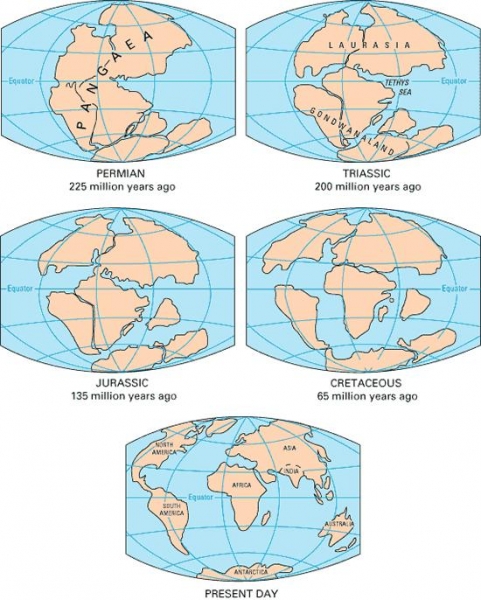
Earth's crust or lithosphere consists of several lithospheric plates.Surface of Earth changes as the lithospheric plates moves.Earth movements arise inside the earth.Temperature and pressure inside the earth changes causes changes on the earth's surface.
According to the theory of continental drift, the world was made up of a single continent through most of geologic time. That continent eventually separated and drifted apart, forming into the seven continents we have today. The first comprehensive theory of continental drift was suggested by the German meteorologist Alfred Wegener in 1912.
Million of year also there was a single continent named "Pangaea". Pangaea broke into pieces due to internal forces and is drifting away from each other since last almost 250 million years.Two landmasses – "Laurasia in North" and "Gondwanaland in South". Both the landmasses were separated by a shallow sea called "Tethys Sea".Size of Tethys Sea kept on decreasing due to movement of landmasses towards each other, thus, resulting in the formation of the young fold mountains "Himalayas".
Theory of Plate Tectonics:
The continental blocks or the plates are floating on mantle. They move with the change or release of pressure and temperature inside the earth.Tectonic movements are of two types:
(a) Vertical Movement: Causes land to uplift or subside or both.
(b) Horizontal Movement: Formation of mountains, trenches in the sea, widening of water bodies, etc. Such movements can cause both folding and faulting of structure.
Folding:
Caused by compression, when blocks of landforms come closer to each other, they form wrinkles or folds on the earth's surface. E.g. the young fold mountains 'Himalayas'. These young fold mountains are formed by sedimentary rocks.
Faulting:
The structure of rocks cracks or breaks along the weaker areas due to tension, this is called faulting. This may cause upliftment and subsidence of land and can form Block Mountains. E.g. Vindhyas and Satpura hills.When a part of land subsides between two faults, it forms Rift Valley. Narmada & Tapti Rivers flow through the rift valley.
Earthquakes:
Effects of earthquakes:
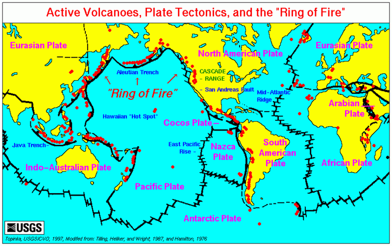
Volcanoes:
Volcanoes are classified into three types: -
(a) Active Volcanoes: These volcanoes erupt frequently and give out gases, ash, lava, etc. e.g. Around Pacific Ocean, Hawaii Islands, etc.
(b) Dormant Volcanoes: These are also known as 'Sleeping Volcanoes'. They erupt after a very long time. E.g. Mt. Vesuvius in Italy.
(c) Extinct Volcanoes: These are also known as 'Dead Volcanoes'. They have been inactive since a very long time. E.g. Mt. Kilimanjaro in East Africa.
MAJOR LAND FORMS
Work of a River: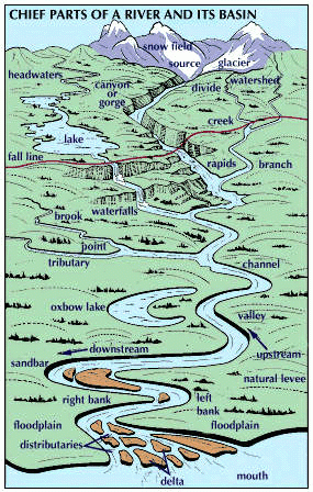
1. Rivers are the most important agents of degradation.
2. Work of the river depends on two factors: -
(a) The volume of Water. (b) Slope of river beds.
3. Common features formed by river while flowing through mountains: -
(a) 'I', 'V' shaped valley. (b) Gorges or Canyons (deep valleys)
(c) Waterfalls, etc.
4. Common features formed by river while flowing through plains: -
(a) Meanders (curves & large bends or loops) (b) Oxbow Lakes
(c) Flood Plains (e) Levees (slightly raised river banks)
5. Common features formed by river when it reaches near the sea: -
(a) River breakup into various streams called 'distributaries'.
(b) Delta
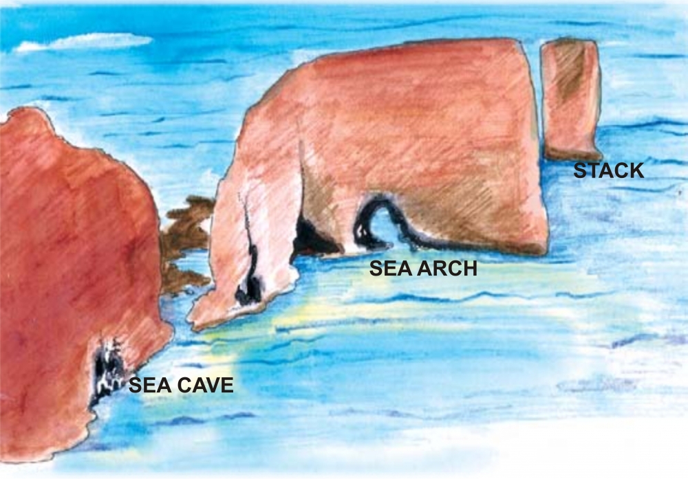
Work of Sea Waves
Work of Ice
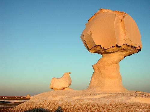
Work of Wind
-----x-----X-----x-----

For Sample question paper:
Links to important websites:
Q1. What is the GREEN Olympiad?
Ans: The GREEN Olympiad is India's first annual examination on environmental issues for middle and senior school students. The examination is designed innovatively to test the knowledge of students and also educate and sensitize them in the process. One of its kind in India, the GREEN Olympiad asks questions on air and water pollution, environment-friendly initiatives and practices, land and water resources, forests, wildlife, oceans, socio-economic aspects of natural resources, global climate change, and the roles of society to improve our environment.
Q2. How do I prepare for the examination?
Ans: There are various ways to brush up your knowledge. Read as many articles as you can on environmental issues in magazines, newspapers, books, journals, encyclopedias. You can watch channels such as Discovery, Animal Planet, National Geographic, etc., on television. Besides this, you could also order a copy of 'Enviro-Challenge': a well-researched question bank containing over 500 questions on diverse topics on environment or you can visit on the websites (link given above).
With Best Wishes