Class IX: Chapter 1 - India: Size and Location
16 August, 2022

_1_o.jpg)
Q1. Explain the divisions of the Himalayas on the basis of regions from west to east.
Ans: On the basis of regions from west to east and the rivers flowing, the great Himalayas have been divided into four divisions:
(a) Punjab Himalayas: This part lies between the Indus and Sutlej. They are also known as Kashmir Himalaya and Himachal Himalaya.
(b) Kumaon Himalayas: This part lies between Sutlej and Kali rivers.
(c) Nepal Himalayas: This part lies between the Kali and Tista rivers.
(d) Assam Himalayas: This part lies between the Tista and Dihang rivers.
Q2. Write short notes on the following:
(a) The Indian Desert (b) The Central Highlands (c) The Island groups of India
Ans:
(a) The Indian Desert: The Indian desert lies towards the western margins of the Aravali Hills. This region gets scanty rainfall which is less than 150 mm in a year. Hence they climate is arid and vegetation is scanty. Luni is the only large river but some streams appear during rainy season. Crescent-shaped dunes (barchans) abound in this area.
(b) The Central Highlands: The Central Highlands lies to the north of the Narmada River. Central Highlands is broadly divided into two: The Malwa Plateau and the Chhotanagpur plateau. It covers the major portion of the Malwa plateau. The rivers in this region flow from southwest to northeast; which indicates the slope of this region. It is wider in the west and narrower in the east. Bundelkhand and Baghelkhand mark the eastward extension of this plateau.
The plateau further extends eastwards into the Chhotanagpur plateau, this area is very rich in minerals.
(c) The Island groups of India: The Lakshadweep Islands are in the Arabian Sea. Its area is 32 sq km. The administrative headquarters of Lakshadweep is at Kavaratti Island. This group of islands is rich in terms of biodiversity.
The Andaman and Nicobar Islands are bigger in size and has more number of islands. Its area is 8249 sq km. This group of islands can be divided into two groups. The Andaman is in the north and the Nicobar is in the south. These islands too have rich biodiversity.
Q3. What are tectonic plates? Name three types of stress build with the plates.
Ans: The crust of the earth is not in the form of a continuous plate rather in the form of broken pieces. These pieces of the earth's crust are called tectonic plates. Broadly, there are seven major plates: African Plate, Antarctic Plate, Eurasian Plate, Indo-Australian Plate, North American Plate, Pacific Plate and South American Plate.
Stress build with the plates leads to Folding, Faulting and Volcanic Activities.
Q4. Which part of India is called Purvachal? Mention few characteristics of Purvachal.
Ans: The Brahmaputra River marks the eastern boundary of the Himalayas. Beyond the Dihang gorge, the Himalayas bend sharply towards south and form the Eastern hills or The Purvachal.
Following are the characteristics of Purvachal:
(a) These hills run through the north eastern states of India.
(b) They are mostly composed of sandstones (i.e. Sedimentary rocks).
(c) These hills are covered with dense forest.
(d) These hills are composed of the Patkai Hills, Naga Hills, Manipuri Hills and Mizo Hills.
Q5. Explain the three major divisions of the Himalayas from north to south.
Ans: Three major divisions of the Himalayas from north to south are:
(a) The Great or Inner Himalaya or Himadri:
• This is the northernmost range and is also known as 'Himadri'.
• This is the most continuous range.
• The average height of peaks in this range is 6,000 meters.
• All the prominent Himalayan peaks are in this range.
• The folds of the Great Himalayas are irregular in nature.
• Because of the lofty heights, the peaks of this range are perennially covered with snow.
• Famous glaciers like the Siachen Glacier, the Gangotri and Yamunotri, etc.
(b) The Lesser Himalaya or Himachal:
• This range lies towards the south of the Great Himalayas.
• The altitude of peaks in this range varies from 3,700 to 4,500 meter.
• Average width of this range is 50 km.
• The most important mountain range here is the Pir Panjal mountain range and it is the longest range. Dhaula Dhar and Mahabharat are also important ranges of lesser Himalayas.
• All great valleys like Kashmir Valley, Kangra Valley, Kullu Valley are present here.
• This region is also known as for its hill stations (for e.g. Kullu,-Manali, Kufri, Shimla, Mussoorie, Nanital, etc.).
(c) The Outer Himalayas or The Shiwaliks:
• The altitude varies between 900 and 1100 meters in this range.
• The width varies between 10 to 50 km.
• These ranges are composed of unconsolidated sediments brought down by the rivers.
The longitudinal valleys lying between the Himachal and Shiwaliks are called 'Dun'. E.g. The dun of Dehra, it is the biggest with a length of 35 km and width of 25 km.
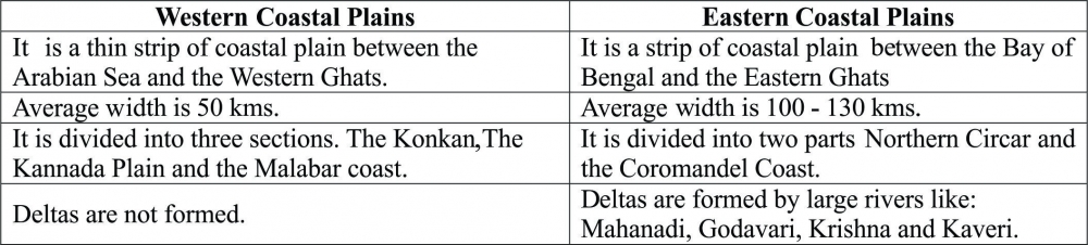
Q6. Distinguish between Western Coastal Plains and Eastern Coastal Plains.
Ans:
Q7. Distinguish between Western Ghats and Eastern Ghats.
Ans:
. eastern & western ghats_1_o.jpg)
Q8. Explain the Northern Plains of India with its divisions.
Ans: The northern plain of India is formed by three river systems, i.e. the Indus, the Ganga and the Brahmaputra; along with their tributaries. This plain is composed of alluvial soil which has been deposited over millions of years. The total area of the northern plain is about 7 lakh square kilometer. It is about 2400 km long. Width is about 240 to 320 km. Northern plains are most densely populated areas of the country. The plains are very fertile and agriculturally very productive.
The northern plain is divided into three sections, i.e. the Punjab Plains, the Ganga Plains and the Brahmaputra Plains.
(a) Punjab Plains: The Punjab plains form the western part of the northern plain. This is formed by the Indus and its tributaries; like Jhelum, Chenab, Ravi, Beas and Sutlej. A major portion of these plains is in Pakistan. Doabs are found in Punjab plains.
(b) Ganga Plains: This plain extends between Ghaggar and Tista rivers. The northern states, Haryana, Delhi, UP, Bihar, part of Jharkhand and West Bengal in the east lie in the Ganga plains.
(c) Brahmaputra Plains: This plain forms the eastern part of the northern plain and lies in Assam.
Based on the relief features; the northern plain can be divided into four regions, viz. Bhabar, Terai, Bhangar and Khadar.
(a) Bhabar: After descending from the mountains, the rivers deposit pebbles in a narrow belt. The width of this belt is about 8 to 16 kms. It lies parallel to the Shiwaliks. Bhabhar is the gently-sloping coarse alluvial zone below the Siwalik Hills (outermost foothills of Himalayas) where streams disappear into permeable sediments. The underground water level is deep in this region.
(b) Terai: The terai region lies towards south of the bhabar belt. In this region, the streams reappear and make a wet, swampy and marshy region. This region was full of forest and wildlife but after partition all this area was cleared and was converted into agricultural land for the settlement of the migrants.
(c) Bhangar: Bhangar is the largest part of the northern plain and is composed of the oldest alluvial soil. They lie above the flood plains. They resemble terraces. The soil of this region is locally known as kankar and is composed of calcareous deposits.
(d) Khadar: The floodplains formed by younger alluvium are called Khadar. The soil in this region is renewed every year and is highly fertile. This region is very suitable for intensive agricultural activities.
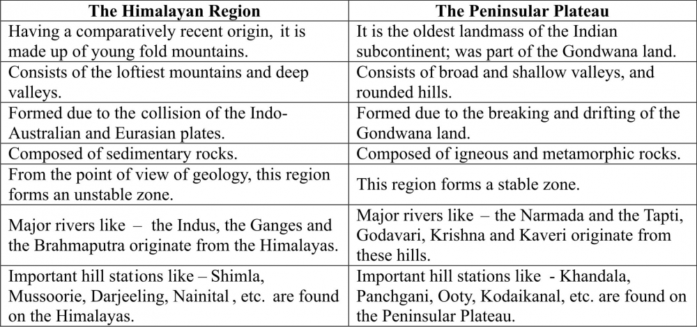
Q9. Contrast the relief of the Himalayan region with that of the Peninsular Plateau.
Ans: The following compares and contrasts between the reliefs of the Himalayan region with that of the Peninsular plateau:
Q10. Map Work: 2016-17_0_o.jpg)
-----x-----X-----x-----
Multiple choice type questions:
Q1. India has got .............. no. of states and ............ no. of union territories?
(a) 29 States 5 union territories
(b) 28 States 8 union territories
(c) 29 States 7 union territories
(d) 28 States 5 union territories
Q2. In India, from Gujarat to Arunachal Pradesh the time lag is?
(a) 2 hrs 05 min.
(b) 2 hrs.
(c) 2 hrs 10 min.
(d) 2 hrs 15 min.
Q3. India is the ....................... largest country in the world?
(a) Second
(b) Fourth
(c) Third
(d) Seventh
Q4. The east-west extent of India is:
(a) 2833 kms
(b) 3214 kms
(c) 2933 kms
(d) 3014 kms
Q5. The land mass of India has an area of ................... million square kms.
(a) 3.18
(b) 3.28
(c) 3.38
(d) 3.48
Q6. India lies in which of the hemisphere?
(a) Northern & Eastern
(b) Southern & Eastern
(c) Northern & Western
(d) Southern & Western
Q7. What is IST?
(a) Indian Stretchable Time
(b) International Standard Time
(c) Indian Stabilized Time
(d) Indian Standard Time
Q8. When was Indira-Point submerged under water?
(a) 2004
(b) 2003
(c) 2005
(d) 2001
Q9. What is the Standard Meridian of India?
(a) 82o 30' West
(b) 82o 30' South
(c) 82o 30' East
(d) 82o 30' North
Q10.Total length of the coast line of the Indian mainland including Andaman and Nicobar and Lakshadweep is?
(a) 7156.6 kms
(b) 7516.6 kms
(c) 7651.6 kms
(d) 7566.6 kms
Q11.Which is the southernmost point of Indian mainland?
(a) Kavarati
(b) Lakshadweep
(c) Kanyakumari
(d) Indira Point
Q12.Suez Canal was opened in the year?
(a) 1869
(b) 1969
(c) 1769
(d) 1896
Q13.The westernmost longitude of India is?
(a) 97o 25' West
(b) 68o 7' West
(c) 68o 7' East
(d) 97o 25' East
Q14. What is the North-South extent of India?
(a) 2833 kms
(b) 3214 kms
(c) 2933 kms
(d) 3014 kms
Q15.Latitudinal and longitudinal extent of India is?
(a) 10o
(b) 20o
(c) 30o
(d) 40o
Q16.Which country shares land boundaries with India in the west?
(a) China
(b) Nepal
(c) Bhutan
(d) Pakistan
Q17.A narrow channel of Sea which separates two land masses is known as:
(a) Mound
(b) Pass
(c) Strait
(d) Valley
Q18.Indian state with the longest coastline on the eastern coast:
(a) Telangana
(b) Andhra Pradesh
(c) Orissa
(d) Tamil Nadu
Q19.What is the latitudinal extent of Indian mainland?
(a) 8o 4' N to 37o 6' N
(b) 6o 4' N to 37o 6' N
(c) 7o 4' N to 36o 7' N
(d) 8o 4' N to 39o 6' N
Q20.Tropic of Cancer does not pass through?
(a) Rajasthan
(b) Chhattisgarh
(c) Orissa
(d) Tripura
-----x-----X-----x-----
Q1. Define: (a) Adolescence (b) Census (c) Death Rate (d) Birth Rate
Ans:
(a) Adolescence: Adolescence is a period in which a person is no longer a child and not yet an adult. Such persons are grouped in the age group of 10 to 19 years.
(b) Census: The official collection of population data by all means is known as Census. This is conducted once in ten years. In 1872, first population census of India was conducted, but the first complete census was conducted in 1881. Currently, we are following 2011 census, this is the fifteenth census starting from 1872.
(c) Death Rate: The number of deaths per 1000 persons is called death rate.
(d) Birth Rate: The number of live births per 1000 persons is called birth rate.
Q2. What is age structure or age composition?
Ans: Number of people in different age groups in country is called age structure or age composition of the population. Population of a nation is generally grouped into three broad categories:
(a) Children (Below 15 years of age): Economically unproductive and needs to be provided with the necessities of life (food, cloth, education, etc.)
(b) Working age (15 – 59 years): Economically and biologically productive
(c) Aged (Above 59 years of age): They can be economically productive even after retirement.
Q3. What are the three major aspects of population study?
Ans: The three major questions to be answered when we study about population are:
(a) Population Size and Distribution.
(b) Population Growth and Process of Population Change.
(c) Characteristics or qualities of the population.
Q4. What is meant by sex ratio? Give reasons for low sex ratio in India.
Ans: Number of female per thousand male is called sex ratio. Following are some of the reasons (mindset of the people) for low sex ratio in India:
(a) Girls in India are taken as a liability, one day she will get married and leave the house; Parents have to pay a huge dowry.
(b) Safety and security is a great concern for family.
(c) India is a male dominated country.
(d) Female Feticide, girl child are killed before her birth.
(e) Females often face Malnutrition, leading to ill health.
Q5. Why is the rate of population growth in India declining since 1981?
Ans: The rate of population growth in India is declining since 1981 because:
(a) The family planning programme initiated by the government made a great impact on the mindset of the people.
(b) Educational programmes have improved the literacy rate helping in increasing the awareness about the benefits of smaller family size.
(c) Parents became aware and wanted to give better quality of life to their children, i.e. good education, food, clothing, health, etc
Q6. What is the relation between occupational structure and development?
Ans: Occupational structure has got a great impact on the development of any country. In India more than 60% of the population is engaged in the agricultural activities and thus, are still dependent on the primary sector for employment, which is one of the reasons for lack of development in India. The developed nations suggest that when a greater portion of population engages in secondary and tertiary activities, it leads to great development.
Q7. What are the advantages of having a healthy population?
Ans: It is rightly said, a healthy mind resides in a healthy body. Human resource is the most important resource for the development of a country. A healthy population helps in building a productive workforce for the country. If the health of the population is properly looked after, people can put in more number of working hours and thus, the production level of the country can be increased. Even the non-productive age group needs to be healthy to reduce the burden of healthcare. Healthy children would grow into healthy adults and would be able to contribute better in the economy. Healthy elders would mean less drain on the resources.
Q8. What is migration? How migration leads to population change?
Ans: Movement of people from one place to another; in search of livelihood is called migration. Migration can be classified into two:
(a) Migration within the country is called internal migration.
(b) Migration between two countries is called international migration.
Internal migration has no change on population size but it changes the population composition of a particular area. International migration can lead to a growth or decline in population; depending on the degree of immigration and emigration.
In India, Poverty and lack of employment opportunities in rural areas work as 'push' factors which result in migration to urban areas. Better employment opportunities in urban areas work as 'pull' factors for migration. Due to increased migration towards urban areas, the share of urban population has increased from 17.29% in 1951 to 27.78% in 2001.
Q9. What are the significant features of the National Population Policy 2000?
Ans: The new national population policy of 2000 was announced by the Government of India, its main features are:
(a) Redress the unmet needs for basic reproductive and child health services, supplies and infrastructure.
(b) Free and compulsory school education up to age 14, for both boys and girls.
(c) Reduce infant mortality rate to below 30 per 1000 live births.
(d) Reduce maternal mortality ratio to below 100 per 100,000 live births.
(e) Achieve universal immunization of children against all vaccine preventable diseases.
(f) Promote delayed marriage for girls, not earlier than age 18 and preferably after 20 years of age.
(g) Achieve 80 per cent institutional deliveries and 100 percent deliveries by trained persons.
(h) Making family welfare a people centered programme.
(i) Preventing and controlling transmissible diseases.
Q10. Map Work (As per 2011 Census)
(A) Densely populated state of India
(B) Less populated state of India
(C) The state of highest density of population
(D) The state of lowest density of population
(E) The state of highest literacy rate
(F) The state of lowest literacy rate
(G) The state of highest sex ratio
(H) The state of lowest sex ratio
Ans:
(A) Densely populated state of India - Uttar Pradesh
(B) Less populated state of India - Sikkim
(C) The state of highest density of population - Bihar
(D) The state of lowest density of population - Arunachal Pradesh
(E) The state of highest literacy rate - Kerala
(F) The state of lowest literacy rate - Bihar
(G) The state of highest sex ratio - Kerala
(H) The state of lowest sex ratio - Haryana
 2016-17_0_o.jpg)
-----x-----X-----x-----